Groessen geodata
Groessen (Gelderland) is a populated place; located in Netherlands in Europe/Amsterdam (GMT+2) time zone. With population of 1,955 people, there are 976 cities with bigger population in this country. Compared to other cities in Netherlands, 55.4% of cities are located further ↑North; 74.6% of cities are located further ←West and 64.6% of cities have lower elevation than Groessen. Note1


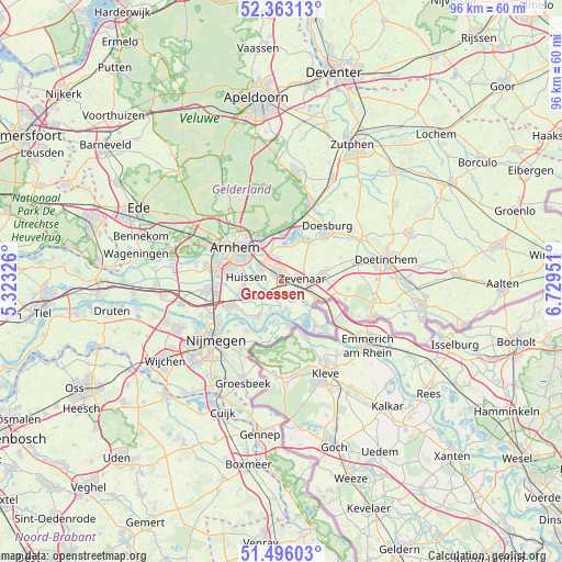
Groessen GPS coordinates[2]
51° 55' 54.012" North, 6° 1' 35.004" East
| Map corner | latitude | longitude |
|---|---|---|
| Upper-left | 52.36313°, | 5.32326° |
| Center: | 51.93167°, | 6.02639° |
| Lower-right: | 51.49603°, | 6.72951° |
| Map W x H: | 96.4×96.4 km | = 59.9×59.9mi |
| max Lat: | 53.48025° ⇑55.4% North |
| Groessen: | 51.93167° |
| min Lat: | ⇓44.6% South 50.76917° |
| min Long | Groessen | max Long |
| 3.38611° | 6.02639° | 7.16528° |
| W 74.6%⇐ | ⇒25.4% E |
Elevation
Elevation of Groessen is 12 m = 39 ft, and this is 3 m = 10 ft below average elevation for this country.
| Max E: |
203 m = 666 ft | 35.4% |
| Avg. | 15 m = 49 ft | |
| Groessen | 12 m = 39 ft | |
Min E: |
-6 m = -20 ft | 64.6% |
See also: Netherlands elevation on elevation.city.
Geographical zone
Groessen is located in North temperate zone (between Tropic of Cancer and the Arctic Circle). Distance of this North polar circle is 1626.9 km =1010.9 mi to North.| Distance of | km | miles | from Groessen |
|---|---|---|---|
| North Pole | 4232.8 | 2630.1 | to North |
| Arctic Circle | 1626.9 | 1010.9 | to North |
| Tropic Cancer | 3168.3 | 1968.7 | to South |
| Equator | 5774.3 | 3588 | to South |


Nearby cities:
15 places around Groessen: (largest is in red/bold)
• Aerdt
5.8 km =3.6 mi,  136°
136°
• Angeren
5 km =3.1 mi,  249°
249°
• Babberich
6.4 km =4 mi,  114°
114°
• Doornenburg
5 km =3.1 mi,  201°
201°
• Duiven
1.9 km =1.2 mi,  332°
332°
• Gendt
7.1 km =4.4 mi,  212°
212°
• Giesbeek
7.4 km =4.6 mi,  21°
21°
• Herwen
7.2 km =4.5 mi, 135°
• Lathum
6.1 km =3.8 mi,  355°
355°
• Ooy
2.6 km =1.6 mi,  122°
122°
• Pannerden
4.6 km =2.9 mi,  169°
169°
• Stegeslag
2.7 km =1.7 mi,  65°
65°
• Westervoort
4.6 km =2.9 mi,  305°
305°
• Zevenaar
3.1 km =1.9 mi,  93°
93°
• Zonnemaat
2.5 km =1.6 mi, 91°
Sources, notices
• [Note1] Compared only with cities in Netherlands existing in our database
• [Src1] Map data: © OpenStreetMap contributors (CC-BY-SA)
• [Src2] Other city data from geonames.org with taken over terms of usage.
• [Src3] Geographical zone / Annual Mean Temperature by Robert A. Rohde @ Wikipedia
