Dreischor geodata
Dreischor (Zeeland) is a populated place; located in Netherlands in Europe/Amsterdam (GMT+2) time zone. With population of 770 people, there are 1553 cities with bigger population in this country. Compared to other cities in Netherlands, 69.3% of cities are located further ↑North; 96.6% of cities are located further →East and 74.9% of cities have higher elevation than Dreischor. Note1


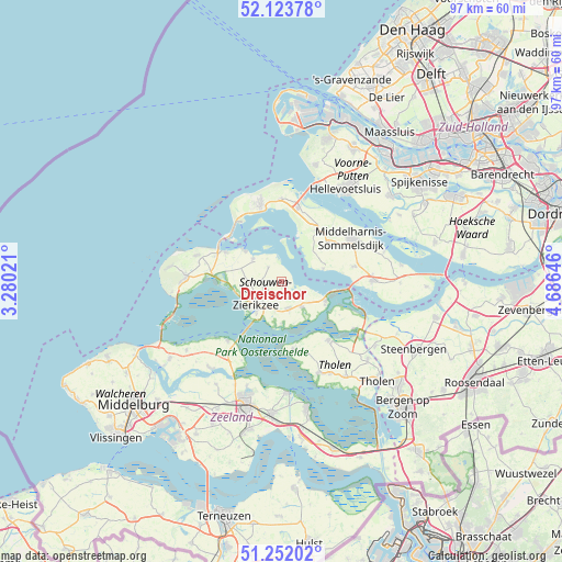
Dreischor GPS coordinates[2]
51° 41' 24" North, 3° 58' 59.988" East
| Map corner | latitude | longitude |
|---|---|---|
| Upper-left | 52.12378°, | 3.28021° |
| Center: | 51.69°, | 3.98333° |
| Lower-right: | 51.25202°, | 4.68646° |
| Map W x H: | 96.9×96.9 km | = 60.2×60.2mi |
| max Lat: | 53.48025° ⇑69.3% North |
| Dreischor: | 51.69° |
| min Lat: | ⇓30.7% South 50.76917° |
| min Long | Dreischor | max Long |
| 3.38611° | 3.98333° | 7.16528° |
| W 3.4%⇐ | ⇒96.6% E |
Elevation
Elevation of Dreischor is 2 m = 7 ft, and this is 13 m = 43 ft below average elevation for this country.
| Max E: |
203 m = 666 ft | 74.9% |
| Avg. | 15 m = 49 ft | |
| Dreischor | 2 m = 7 ft | |
Min E: |
-6 m = -20 ft | 25.1% |
See also: Netherlands elevation on elevation.city.
Geographical zone
Dreischor is located in North temperate zone (between Tropic of Cancer and the Arctic Circle). Distance of this North polar circle is 1653.8 km =1027.6 mi to North.| Distance of | km | miles | from Dreischor |
|---|---|---|---|
| North Pole | 4259.7 | 2646.9 | to North |
| Arctic Circle | 1653.8 | 1027.6 | to North |
| Tropic Cancer | 3141.5 | 1952 | to South |
| Equator | 5747.4 | 3571.3 | to South |


Nearby cities:
15 places around Dreischor: (largest is in red/bold)
• Brouwershaven
6.4 km =4 mi,  309°
309°
• Bruinisse
8.3 km =5.2 mi,  112°
112°
• Colijnsplaat
13.7 km =8.5 mi,  222°
222°
• Dirksland
10.4 km =6.5 mi,  50°
50°
• Goedereede
14.2 km =8.8 mi,  359°
359°
• Kerkwerve
5.9 km =3.7 mi,  266°
266°
• Malta
5.6 km =3.5 mi, 217°
• Middelharnis
14.6 km =9.1 mi,  59°
59°
• Nieuwerkerk
4.5 km =2.8 mi,  164°
164°
• Oosterland
5.7 km =3.5 mi,  140°
140°
• Ouddorp
13.9 km =8.6 mi,  346°
346°
• Scharendijke
10.9 km =6.8 mi,  297°
297°
• Stavenisse
11.6 km =7.2 mi,  169°
169°
• Zierikzee
6.3 km =3.9 mi, 224°
• Zonnemaire
3.4 km =2.1 mi,  319°
319°
Sources, notices
• [Note1] Compared only with cities in Netherlands existing in our database
• [Src1] Map data: © OpenStreetMap contributors (CC-BY-SA)
• [Src2] Other city data from geonames.org with taken over terms of usage.
• [Src3] Geographical zone / Annual Mean Temperature by Robert A. Rohde @ Wikipedia
