Stavenisse geodata
Stavenisse (Zeeland) is a populated place; located in Netherlands in Europe/Amsterdam (GMT+2) time zone. With population of 1,505 people, there are 1125 cities with bigger population in this country. Compared to other cities in Netherlands, 74.5% of cities are located further ↑North; 96.4% of cities are located further →East and 74.9% of cities have higher elevation than Stavenisse. Note1


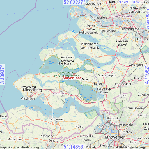
Stavenisse GPS coordinates[2]
51° 35' 15" North, 4° 0' 45" East
| Map corner | latitude | longitude |
|---|---|---|
| Upper-left | 52.02227°, | 3.30937° |
| Center: | 51.5875°, | 4.0125° |
| Lower-right: | 51.14853°, | 4.71562° |
| Map W x H: | 97.2×97.1 km | = 60.4×60.3mi |
| max Lat: | 53.48025° ⇑74.5% North |
| Stavenisse: | 51.5875° |
| min Lat: | ⇓25.5% South 50.76917° |
| min Long | Stavenisse | max Long |
| 3.38611° | 4.0125° | 7.16528° |
| W 3.6%⇐ | ⇒96.4% E |
Elevation
Elevation of Stavenisse is 2 m = 7 ft, and this is 13 m = 43 ft below average elevation for this country.
| Max E: |
203 m = 666 ft | 74.9% |
| Avg. | 15 m = 49 ft | |
| Stavenisse | 2 m = 7 ft | |
Min E: |
-6 m = -20 ft | 25.1% |
See also: Netherlands elevation on elevation.city.
Geographical zone
Stavenisse is located in North temperate zone (between Tropic of Cancer and the Arctic Circle). Distance of this North polar circle is 1665.2 km =1034.7 mi to North.| Distance of | km | miles | from Stavenisse |
|---|---|---|---|
| North Pole | 4271.1 | 2653.9 | to North |
| Arctic Circle | 1665.2 | 1034.7 | to North |
| Tropic Cancer | 3130.1 | 1945 | to South |
| Equator | 5736 | 3564.2 | to South |


Nearby cities:
15 places around Stavenisse: (largest is in red/bold)
• Bruinisse
10 km =6.2 mi,  34°
34°
• Colijnsplaat
11.4 km =7.1 mi,  276°
276°
• Dreischor
11.6 km =7.2 mi,  349°
349°
• Kapelle
11.9 km =7.4 mi,  198°
198°
• Kloetinge
12 km =7.5 mi,  214°
214°
• Malta
8.8 km =5.5 mi,  321°
321°
• Nieuwerkerk
7.1 km =4.4 mi, 353°
• Oosterland
7.1 km =4.4 mi,  13°
13°
• Poortvliet
10.2 km =6.3 mi,  118°
118°
• Scherpenisse
7.9 km =4.9 mi,  125°
125°
• Sint Philipsland
11 km =6.8 mi,  72°
72°
• Wemeldinge
7.8 km =4.8 mi,  187°
187°
• Wilhelminadorp
10.3 km =6.4 mi,  230°
230°
• Yerseke
10.9 km =6.8 mi,  166°
166°
• Zierikzee
9.5 km =5.9 mi, 317°
Sources, notices
• [Note1] Compared only with cities in Netherlands existing in our database
• [Src1] Map data: © OpenStreetMap contributors (CC-BY-SA)
• [Src2] Other city data from geonames.org with taken over terms of usage.
• [Src3] Geographical zone / Annual Mean Temperature by Robert A. Rohde @ Wikipedia
