Bunde geodata
Bunde (Limburg) is a populated place; located in Netherlands in Europe/Amsterdam (GMT+2) time zone. With population of 5,500 people, there are 440 cities with bigger population in this country. Compared to other cities in Netherlands, 96.4% of cities are located further ↑North; 53.6% of cities are located further ←West and 93.4% of cities have lower elevation than Bunde. Note1


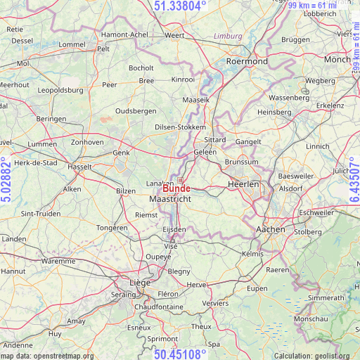
Bunde GPS coordinates[2]
50° 53' 48.012" North, 5° 43' 54.984" East
| Map corner | latitude | longitude |
|---|---|---|
| Upper-left | 51.33804°, | 5.02882° |
| Center: | 50.89667°, | 5.73194° |
| Lower-right: | 50.45108°, | 6.43507° |
| Map W x H: | 98.6×98.6 km | = 61.3×61.3mi |
| max Lat: | 53.48025° ⇑96.4% North |
| Bunde: | 50.89667° |
| min Lat: | ⇓3.6% South 50.76917° |
| min Long | Bunde | max Long |
| 3.38611° | 5.73194° | 7.16528° |
| W 53.6%⇐ | ⇒46.4% E |
Elevation
Elevation of Bunde is 49 m = 161 ft, and this is 34 m = 112 ft above average elevation for this country.
| Max E: |
203 m = 666 ft | 6.6% |
| Bunde | 49 m 161 ft | |
| Avg. | 15 m = 49 ft | |
Min E: |
-6 m = -20 ft | 93.4% |
See also: Netherlands elevation on elevation.city.
Geographical zone
Bunde is located in North temperate zone (between Tropic of Cancer and the Arctic Circle). Distance of this North polar circle is 1742 km =1082.4 mi to North.| Distance of | km | miles | from Bunde |
|---|---|---|---|
| North Pole | 4347.9 | 2701.7 | to North |
| Arctic Circle | 1742 | 1082.4 | to North |
| Tropic Cancer | 3053.3 | 1897.2 | to South |
| Equator | 5659.2 | 3516.5 | to South |


Nearby cities:
15 places around Bunde: (largest is in red/bold)
• Amby
3.8 km =2.4 mi,  179°
179°
• Berg
5.3 km =3.3 mi,  137°
137°
• Borgharen
3.8 km =2.4 mi,  235°
235°
• Catsop
5.3 km =3.3 mi,  27°
27°
• Elsloo
6.4 km =4 mi, 25°
• Houthem
5.1 km =3.2 mi,  122°
122°
• Itteren
2.1 km =1.3 mi,  275°
275°
• Limmel
3.7 km =2.3 mi,  207°
207°
• Maastricht
6.2 km =3.9 mi, 209°
• Meerssen
1.6 km =1 mi,  128°
128°
• Oud-Caberg
5.9 km =3.7 mi,  233°
233°
• Rothem
2.3 km =1.4 mi,  167°
167°
• Scharn
5.2 km =3.2 mi, 178°
• Sint Gerlach
5.1 km =3.2 mi, 123°
• Ulestraten
3.7 km =2.3 mi,  73°
73°
Sources, notices
• [Note1] Compared only with cities in Netherlands existing in our database
• [Src1] Map data: © OpenStreetMap contributors (CC-BY-SA)
• [Src2] Other city data from geonames.org with taken over terms of usage.
• [Src3] Geographical zone / Annual Mean Temperature by Robert A. Rohde @ Wikipedia
