Brunssum geodata
Brunssum (Limburg) is a populated place; located in Netherlands in Europe/Amsterdam (GMT+2) time zone. With population of 29,254 people, there are 108 cities with bigger population in this country. Compared to other cities in Netherlands, 94.7% of cities are located further ↑North; 70.1% of cities are located further ←West and 95.9% of cities have lower elevation than Brunssum. Note1


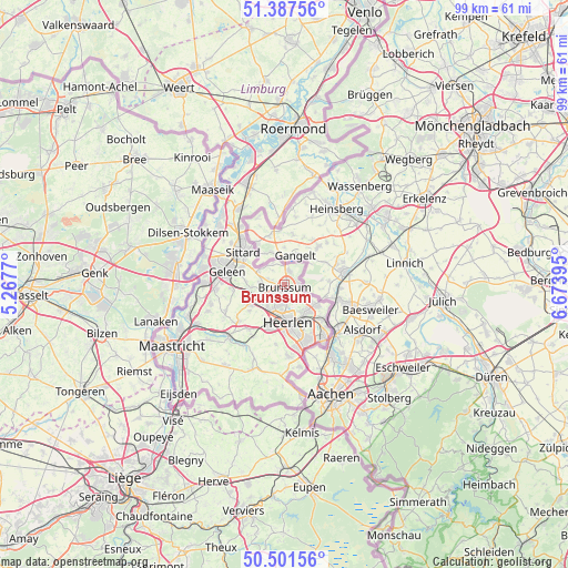
Brunssum GPS coordinates[2]
50° 56' 48.012" North, 5° 58' 14.988" East
| Map corner | latitude | longitude |
|---|---|---|
| Upper-left | 51.38756°, | 5.2677° |
| Center: | 50.94667°, | 5.97083° |
| Lower-right: | 50.50156°, | 6.67395° |
| Map W x H: | 98.5×98.5 km | = 61.2×61.2mi |
| max Lat: | 53.48025° ⇑94.7% North |
| Brunssum: | 50.94667° |
| min Lat: | ⇓5.3% South 50.76917° |
| min Long | Brunssum | max Long |
| 3.38611° | 5.97083° | 7.16528° |
| W 70.1%⇐ | ⇒29.9% E |
Elevation
Elevation of Brunssum is 79 m = 259 ft, and this is 64 m = 210 ft above average elevation for this country.
| Max E: |
203 m = 666 ft | 4.1% |
| Brunssum | 79 m 259 ft | |
| Avg. | 15 m = 49 ft | |
Min E: |
-6 m = -20 ft | 95.9% |
See also: Netherlands elevation on elevation.city.
Geographical zone
Brunssum is located in North temperate zone (between Tropic of Cancer and the Arctic Circle). Distance of this North polar circle is 1736.4 km =1078.9 mi to North.| Distance of | km | miles | from Brunssum |
|---|---|---|---|
| North Pole | 4342.3 | 2698.2 | to North |
| Arctic Circle | 1736.4 | 1078.9 | to North |
| Tropic Cancer | 3058.8 | 1900.6 | to South |
| Equator | 5664.7 | 3519.9 | to South |


Nearby cities:
15 places around Brunssum: (largest is in red/bold)
• Amstenrade
3.4 km =2.1 mi,  255°
255°
• Beersdal
4.5 km =2.8 mi,  185°
185°
• Bingelrade
4.5 km =2.8 mi,  316°
316°
• Heksenberg
2.9 km =1.8 mi,  175°
175°
• Hoensbroek
4.1 km =2.5 mi,  231°
231°
• Hommert
4.1 km =2.5 mi,  252°
252°
• Jabeek
4.3 km =2.7 mi,  331°
331°
• Kruisberg
0.6 km =0.4 mi,  219°
219°
• Mariarade
3.6 km =2.2 mi,  237°
237°
• Merkelbeek
2.3 km =1.4 mi,  290°
290°
• Oirsbeek
4.4 km =2.7 mi,  276°
276°
• Passart
3 km =1.9 mi,  213°
213°
• Schinveld
2.6 km =1.6 mi,  13°
13°
• Schuttersveld
0.9 km =0.6 mi,  104°
104°
• Vrieheide
2.8 km =1.7 mi, 185°
Sources, notices
• [Note1] Compared only with cities in Netherlands existing in our database
• [Src1] Map data: © OpenStreetMap contributors (CC-BY-SA)
• [Src2] Other city data from geonames.org with taken over terms of usage.
• [Src3] Geographical zone / Annual Mean Temperature by Robert A. Rohde @ Wikipedia
