Bingelrade geodata
Bingelrade (Limburg) is a populated place; located in Netherlands in Europe/Amsterdam (GMT+2) time zone. With population of 825 people, there are 1509 cities with bigger population in this country. Compared to other cities in Netherlands, 93.9% of cities are located further ↑North; 66% of cities are located further ←West and 95.7% of cities have lower elevation than Bingelrade. Note1


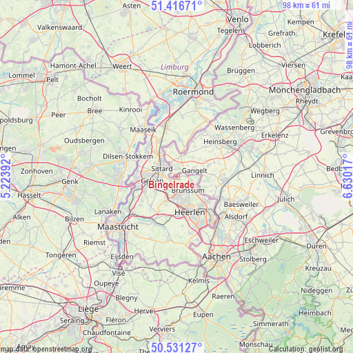
Bingelrade GPS coordinates[2]
50° 58' 33.96" North, 5° 55' 37.344" East
| Map corner | latitude | longitude |
|---|---|---|
| Upper-left | 51.41671°, | 5.22392° |
| Center: | 50.9761°, | 5.92704° |
| Lower-right: | 50.53127°, | 6.63017° |
| Map W x H: | 98.5×98.4 km | = 61.2×61.1mi |
| max Lat: | 53.48025° ⇑93.9% North |
| Bingelrade: | 50.9761° |
| min Lat: | ⇓6.1% South 50.76917° |
| min Long | Bingelrade | max Long |
| 3.38611° | 5.92704° | 7.16528° |
| W 66%⇐ | ⇒34% E |
Elevation
Elevation of Bingelrade is 77 m = 253 ft, and this is 62 m = 203 ft above average elevation for this country.
| Max E: |
203 m = 666 ft | 4.3% |
| Bingelrade | 77 m 253 ft | |
| Avg. | 15 m = 49 ft | |
Min E: |
-6 m = -20 ft | 95.7% |
See also: Netherlands elevation on elevation.city.
Geographical zone
Bingelrade is located in North temperate zone (between Tropic of Cancer and the Arctic Circle). Distance of this North polar circle is 1733.2 km =1077 mi to North.| Distance of | km | miles | from Bingelrade |
|---|---|---|---|
| North Pole | 4339.1 | 2696.2 | to North |
| Arctic Circle | 1733.2 | 1077 | to North |
| Tropic Cancer | 3062.1 | 1902.7 | to South |
| Equator | 5668 | 3521.9 | to South |


Nearby cities:
15 places around Bingelrade: (largest is in red/bold)
• Amstenrade
4.1 km =2.5 mi,  183°
183°
• Broeksittard
3.7 km =2.3 mi,  323°
323°
• Brunssum
4.5 km =2.8 mi,  136°
136°
• Doenrade
1.7 km =1.1 mi,  235°
235°
• Hommert
4.6 km =2.9 mi,  190°
190°
• Jabeek
1.2 km =0.7 mi,  62°
62°
• Kruisberg
4.6 km =2.9 mi, 144°
• Merkelbeek
2.6 km =1.6 mi,  158°
158°
• Munstergeleen
4.4 km =2.7 mi,  268°
268°
• Oirsbeek
3.1 km =1.9 mi,  205°
205°
• Puth
4.5 km =2.8 mi, 236°
• Schinnen
4.5 km =2.8 mi,  216°
216°
• Schinveld
3.7 km =2.3 mi,  101°
101°
• Sittard
4.7 km =2.9 mi,  301°
301°
• Stadbroek
4.5 km =2.8 mi,  309°
309°
Sources, notices
• [Note1] Compared only with cities in Netherlands existing in our database
• [Src1] Map data: © OpenStreetMap contributors (CC-BY-SA)
• [Src2] Other city data from geonames.org with taken over terms of usage.
• [Src3] Geographical zone / Annual Mean Temperature by Robert A. Rohde @ Wikipedia
