Jabeek geodata
Jabeek (Limburg) is a populated place; located in Netherlands in Europe/Amsterdam (GMT+2) time zone. With population of 700 people, there are 1626 cities with bigger population in this country. Compared to other cities in Netherlands, 93.8% of cities are located further ↑North; 67.1% of cities are located further ←West and 94.6% of cities have lower elevation than Jabeek. Note1


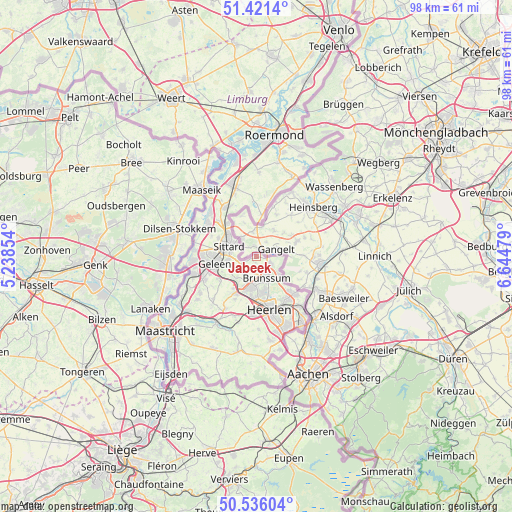
Jabeek GPS coordinates[2]
50° 58' 50.988" North, 5° 56' 30.012" East
| Map corner | latitude | longitude |
|---|---|---|
| Upper-left | 51.4214°, | 5.23854° |
| Center: | 50.98083°, | 5.94167° |
| Lower-right: | 50.53604°, | 6.64479° |
| Map W x H: | 98.4×98.4 km | = 61.1×61.1mi |
| max Lat: | 53.48025° ⇑93.8% North |
| Jabeek: | 50.98083° |
| min Lat: | ⇓6.2% South 50.76917° |
| min Long | Jabeek | max Long |
| 3.38611° | 5.94167° | 7.16528° |
| W 67.1%⇐ | ⇒32.9% E |
Elevation
Elevation of Jabeek is 62 m = 203 ft, and this is 47 m = 154 ft above average elevation for this country.
| Max E: |
203 m = 666 ft | 5.4% |
| Jabeek | 62 m 203 ft | |
| Avg. | 15 m = 49 ft | |
Min E: |
-6 m = -20 ft | 94.6% |
See also: Netherlands elevation on elevation.city.
Geographical zone
Jabeek is located in North temperate zone (between Tropic of Cancer and the Arctic Circle). Distance of this North polar circle is 1732.6 km =1076.6 mi to North.| Distance of | km | miles | from Jabeek |
|---|---|---|---|
| North Pole | 4338.5 | 2695.8 | to North |
| Arctic Circle | 1732.6 | 1076.6 | to North |
| Tropic Cancer | 3062.6 | 1903 | to South |
| Equator | 5668.5 | 3522.2 | to South |


Nearby cities:
15 places around Jabeek: (largest is in red/bold)
• Amstenrade
4.8 km =3 mi,  195°
195°
• Bingelrade
1.2 km =0.7 mi,  242°
242°
• Broeksittard
4.1 km =2.5 mi,  306°
306°
• Brunssum
4.3 km =2.7 mi,  151°
151°
• Doenrade
2.8 km =1.7 mi, 238°
• Hommert
5.3 km =3.3 mi, 200°
• Kruisberg
4.6 km =2.9 mi,  158°
158°
• Merkelbeek
3 km =1.9 mi,  181°
181°
• Munstergeleen
5.5 km =3.4 mi,  263°
263°
• Oirsbeek
4.1 km =2.5 mi,  214°
214°
• Schinnen
5.6 km =3.5 mi,  221°
221°
• Schinveld
2.9 km =1.8 mi,  116°
116°
• Schuttersveld
5 km =3.1 mi,  144°
144°
• Sittard
5.4 km =3.4 mi,  291°
291°
• Stadbroek
5.1 km =3.2 mi,  297°
297°
Sources, notices
• [Note1] Compared only with cities in Netherlands existing in our database
• [Src1] Map data: © OpenStreetMap contributors (CC-BY-SA)
• [Src2] Other city data from geonames.org with taken over terms of usage.
• [Src3] Geographical zone / Annual Mean Temperature by Robert A. Rohde @ Wikipedia
