Burgum geodata
Burgum (Friesland) is a populated place; located in Netherlands in Europe/Amsterdam (GMT+2) time zone. With population of 9,720 people, there are 296 cities with bigger population in this country. Compared to other cities in Netherlands, 92.7% of cities are located further ↓South; 71.9% of cities are located further ←West and 65.8% of cities have higher elevation than Burgum. Note1


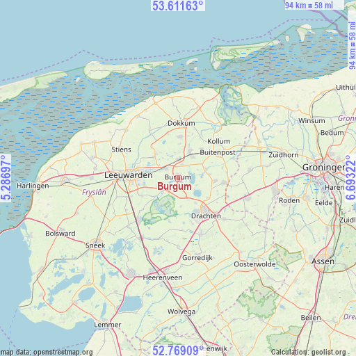
Burgum GPS coordinates[2]
53° 11' 32.748" North, 5° 59' 24.324" East
| Map corner | latitude | longitude |
|---|---|---|
| Upper-left | 53.61163°, | 5.28697° |
| Center: | 53.19243°, | 5.99009° |
| Lower-right: | 52.76909°, | 6.69322° |
| Map W x H: | 93.7×93.7 km | = 58.2×58.2mi |
| max Lat: | 53.48025° ⇑7.3% North |
| Burgum: | 53.19243° |
| min Lat: | ⇓92.7% South 50.76917° |
| min Long | Burgum | max Long |
| 3.38611° | 5.99009° | 7.16528° |
| W 71.9%⇐ | ⇒28.1% E |
Elevation
Elevation of Burgum is 3 m = 10 ft, and this is 12 m = 39 ft below average elevation for this country.
| Max E: |
203 m = 666 ft | 65.8% |
| Avg. | 15 m = 49 ft | |
| Burgum | 3 m = 10 ft | |
Min E: |
-6 m = -20 ft | 34.2% |
See also: Netherlands elevation on elevation.city.
Geographical zone
Burgum is located in North temperate zone (between Tropic of Cancer and the Arctic Circle). Distance of this North polar circle is 1486.7 km =923.8 mi to North.| Distance of | km | miles | from Burgum |
|---|---|---|---|
| North Pole | 4092.6 | 2543 | to North |
| Arctic Circle | 1486.7 | 923.8 | to North |
| Tropic Cancer | 3308.5 | 2055.8 | to South |
| Equator | 5914.4 | 3675 | to South |


Nearby cities:
15 places around Burgum: (largest is in red/bold)
• Eastermar
5.1 km =3.2 mi,  112°
112°
• Feanwâlden
4.8 km =3 mi,  358°
358°
• Garyp
3.3 km =2.1 mi,  208°
208°
• Hurdegaryp
4 km =2.5 mi,  305°
305°
• Jistrum
5.5 km =3.4 mi,  67°
67°
• Kootstertille
7.2 km =4.5 mi, 71°
• Noardburgum
3.4 km =2.1 mi,  17°
17°
• Oudega
7.5 km =4.7 mi,  175°
175°
• Ryptsjerk
5.9 km =3.7 mi,  304°
304°
• Sumar
1.2 km =0.7 mi,  146°
146°
• Suwâld
4.5 km =2.8 mi,  249°
249°
• Twijzelerheide
6.5 km =4 mi,  35°
35°
• Tytsjerk
5.8 km =3.6 mi,  293°
293°
• Warten
7.6 km =4.7 mi,  231°
231°
• Zwagerbosch
7.3 km =4.5 mi,  31°
31°
Sources, notices
• [Note1] Compared only with cities in Netherlands existing in our database
• [Src1] Map data: © OpenStreetMap contributors (CC-BY-SA)
• [Src2] Other city data from geonames.org with taken over terms of usage.
• [Src3] Geographical zone / Annual Mean Temperature by Robert A. Rohde @ Wikipedia
