Eastermar geodata
Eastermar (Friesland) is a populated place; located in Netherlands in Europe/Amsterdam (GMT+2) time zone. With population of 1,310 people, there are 1233 cities with bigger population in this country. Compared to other cities in Netherlands, 91.9% of cities are located further ↓South; 76.7% of cities are located further ←West and 83.9% of cities have higher elevation than Eastermar. Note1


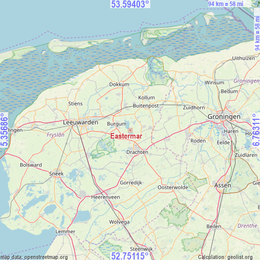
Eastermar GPS coordinates[2]
53° 10' 28.776" North, 6° 3' 35.964" East
| Map corner | latitude | longitude |
|---|---|---|
| Upper-left | 53.59403°, | 5.35686° |
| Center: | 53.17466°, | 6.05999° |
| Lower-right: | 52.75115°, | 6.76311° |
| Map W x H: | 93.7×93.7 km | = 58.2×58.2mi |
| max Lat: | 53.48025° ⇑8.1% North |
| Eastermar: | 53.17466° |
| min Lat: | ⇓91.9% South 50.76917° |
| min Long | Eastermar | max Long |
| 3.38611° | 6.05999° | 7.16528° |
| W 76.7%⇐ | ⇒23.3% E |
Elevation
Elevation of Eastermar is 1 m = 3 ft, and this is 14 m = 46 ft below average elevation for this country.
| Max E: |
203 m = 666 ft | 83.9% |
| Avg. | 15 m = 49 ft | |
| Eastermar | 1 m = 3 ft | |
Min E: |
-6 m = -20 ft | 16.1% |
See also: Netherlands elevation on elevation.city.
Geographical zone
Eastermar is located in North temperate zone (between Tropic of Cancer and the Arctic Circle). Distance of this North polar circle is 1488.7 km =925 mi to North.| Distance of | km | miles | from Eastermar |
|---|---|---|---|
| North Pole | 4094.6 | 2544.3 | to North |
| Arctic Circle | 1488.7 | 925 | to North |
| Tropic Cancer | 3306.5 | 2054.6 | to South |
| Equator | 5912.5 | 3673.9 | to South |


Nearby cities:
15 places around Eastermar: (largest is in red/bold)
• Boelenslaan
5.8 km =3.6 mi,  104°
104°
• Burgum
5.1 km =3.2 mi,  292°
292°
• Drachtstercompagnie
7 km =4.3 mi,  129°
129°
• Drogeham
4.6 km =2.9 mi,  48°
48°
• Garyp
6.3 km =3.9 mi,  261°
261°
• Harkema
5 km =3.1 mi,  78°
78°
• Houtigehage
6.2 km =3.9 mi,  113°
113°
• Jistrum
4.1 km =2.5 mi,  6°
6°
• Kootstertille
4.7 km =2.9 mi,  26°
26°
• Noardburgum
6.3 km =3.9 mi,  324°
324°
• Opeinde
4.5 km =2.8 mi,  182°
182°
• Oudega
6.9 km =4.3 mi,  216°
216°
• Rottevalle
4.4 km =2.7 mi,  138°
138°
• Sumar
4.1 km =2.5 mi,  283°
283°
• Twijzel
6.6 km =4.1 mi,  17°
17°
Sources, notices
• [Note1] Compared only with cities in Netherlands existing in our database
• [Src1] Map data: © OpenStreetMap contributors (CC-BY-SA)
• [Src2] Other city data from geonames.org with taken over terms of usage.
• [Src3] Geographical zone / Annual Mean Temperature by Robert A. Rohde @ Wikipedia
