Ammerzoden geodata
Ammerzoden (Gelderland) is a populated place; located in Netherlands in Europe/Amsterdam (GMT+2) time zone. With population of 3,040 people, there are 750 cities with bigger population in this country. Compared to other cities in Netherlands, 66.9% of cities are located further ↑North; 66% of cities are located further →East and 65.8% of cities have higher elevation than Ammerzoden. Note1


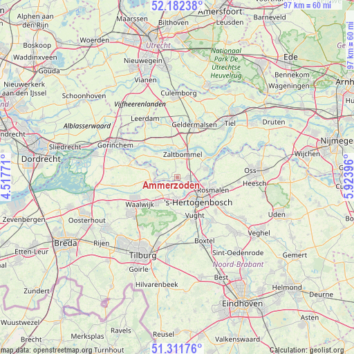
Ammerzoden GPS coordinates[2]
51° 44' 57.012" North, 5° 13' 14.988" East
| Map corner | latitude | longitude |
|---|---|---|
| Upper-left | 52.18238°, | 4.51771° |
| Center: | 51.74917°, | 5.22083° |
| Lower-right: | 51.31176°, | 5.92396° |
| Map W x H: | 96.8×96.8 km | = 60.1×60.1mi |
| max Lat: | 53.48025° ⇑66.9% North |
| Ammerzoden: | 51.74917° |
| min Lat: | ⇓33.1% South 50.76917° |
| min Long | Ammerzoden | max Long |
| 3.38611° | 5.22083° | 7.16528° |
| W 34%⇐ | ⇒66% E |
Elevation
Elevation of Ammerzoden is 3 m = 10 ft, and this is 12 m = 39 ft below average elevation for this country.
| Max E: |
203 m = 666 ft | 65.8% |
| Avg. | 15 m = 49 ft | |
| Ammerzoden | 3 m = 10 ft | |
Min E: |
-6 m = -20 ft | 34.2% |
See also: Netherlands elevation on elevation.city.
Geographical zone
Ammerzoden is located in North temperate zone (between Tropic of Cancer and the Arctic Circle). Distance of this North polar circle is 1647.2 km =1023.5 mi to North.| Distance of | km | miles | from Ammerzoden |
|---|---|---|---|
| North Pole | 4253.1 | 2642.8 | to North |
| Arctic Circle | 1647.2 | 1023.5 | to North |
| Tropic Cancer | 3148 | 1956.1 | to South |
| Equator | 5754 | 3575.4 | to South |


Nearby cities:
15 places around Ammerzoden: (largest is in red/bold)
• Aalburg
6.2 km =3.9 mi,  275°
275°
• Bruchem
4.3 km =2.7 mi,  14°
14°
• De Kruiskamp
6.1 km =3.8 mi,  153°
153°
• Gameren
5.9 km =3.7 mi,  348°
348°
• Haarsteeg
4.4 km =2.7 mi,  200°
200°
• Hedel
2.8 km =1.7 mi,  92°
92°
• Herpt
5 km =3.1 mi,  243°
243°
• Heusden
5.9 km =3.7 mi,  253°
253°
• Nederhemert
4 km =2.5 mi,  296°
296°
• Nederhemert-Noord
3.6 km =2.2 mi, 295°
• Nieuwkuijk
7.1 km =4.4 mi, 202°
• Spijk
7.2 km =4.5 mi,  287°
287°
• Velddriel
6.1 km =3.8 mi,  68°
68°
• Vliedberg
6.9 km =4.3 mi, 197°
• Zaltbommel
7 km =4.3 mi, 13°
Sources, notices
• [Note1] Compared only with cities in Netherlands existing in our database
• [Src1] Map data: © OpenStreetMap contributors (CC-BY-SA)
• [Src2] Other city data from geonames.org with taken over terms of usage.
• [Src3] Geographical zone / Annual Mean Temperature by Robert A. Rohde @ Wikipedia
