Nederhemert-Noord geodata
Nederhemert-Noord (Gelderland) is a section of populated place; located in Netherlands in Europe/Amsterdam (GMT+2) time zone. With population of 1,490 people, there are 1138 cities with bigger population in this country. Compared to other cities in Netherlands, 66.4% of cities are located further ↑North; 67.4% of cities are located further →East and 58.8% of cities have higher elevation than Nederhemert-Noord. Note1


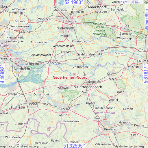
Nederhemert-Noord GPS coordinates[2]
51° 45' 47.592" North, 5° 10' 22.98" East
| Map corner | latitude | longitude |
|---|---|---|
| Upper-left | 52.1963°, | 4.46992° |
| Center: | 51.76322°, | 5.17305° |
| Lower-right: | 51.32595°, | 5.87617° |
| Map W x H: | 96.8×96.8 km | = 60.1×60.1mi |
| max Lat: | 53.48025° ⇑66.4% North |
| Nederhemert-Noord: | 51.76322° |
| min Lat: | ⇓33.6% South 50.76917° |
| min Long | Nederhemert-Noo | max Long |
| 3.38611° | 5.17305° | 7.16528° |
| W 32.6%⇐ | ⇒67.4% E |
Elevation
Elevation of Nederhemert-Noord is 4 m = 13 ft, and this is 11 m = 36 ft below average elevation for this country.
| Max E: |
203 m = 666 ft | 58.8% |
| Avg. | 15 m = 49 ft | |
| Nederhemert-Noord | 4 m = 13 ft | |
Min E: |
-6 m = -20 ft | 41.2% |
See also: Netherlands elevation on elevation.city.
Geographical zone
Nederhemert-Noord is located in North temperate zone (between Tropic of Cancer and the Arctic Circle). Distance of this North polar circle is 1645.6 km =1022.5 mi to North.| Distance of | km | miles | from Nederhemert-Noord |
|---|---|---|---|
| North Pole | 4251.5 | 2641.8 | to North |
| Arctic Circle | 1645.6 | 1022.5 | to North |
| Tropic Cancer | 3149.6 | 1957.1 | to South |
| Equator | 5755.5 | 3576.3 | to South |


Nearby cities:
15 places around Nederhemert-Noord: (largest is in red/bold)
• Aalburg
3 km =1.9 mi,  251°
251°
• Aalst
3.8 km =2.4 mi,  304°
304°
• Ammerzoden
3.6 km =2.2 mi,  115°
115°
• Bruchem
5.1 km =3.2 mi,  58°
58°
• Gameren
4.7 km =2.9 mi,  27°
27°
• Haaften
6.4 km =4 mi,  24°
24°
• Haarsteeg
6 km =3.7 mi,  162°
162°
• Hedel
6.3 km =3.9 mi,  105°
105°
• Herpt
4 km =2.5 mi,  197°
197°
• Heusden
4 km =2.5 mi,  216°
216°
• Nederhemert
0.4 km =0.2 mi, 302°
• Nieuwaal
5.2 km =3.2 mi,  3°
3°
• Spijk
3.7 km =2.3 mi,  280°
280°
• Veen
4.7 km =2.9 mi,  289°
289°
• Zuilichem
5.7 km =3.5 mi,  333°
333°
Sources, notices
• [Note1] Compared only with cities in Netherlands existing in our database
• [Src1] Map data: © OpenStreetMap contributors (CC-BY-SA)
• [Src2] Other city data from geonames.org with taken over terms of usage.
• [Src3] Geographical zone / Annual Mean Temperature by Robert A. Rohde @ Wikipedia
