Hedel geodata
Hedel (Gelderland) is a populated place; located in Netherlands in Europe/Amsterdam (GMT+2) time zone. With population of 4,350 people, there are 551 cities with bigger population in this country. Compared to other cities in Netherlands, 67% of cities are located further ↑North; 64.7% of cities are located further →East and 58.8% of cities have higher elevation than Hedel. Note1


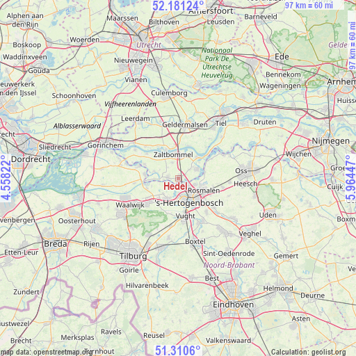
Hedel GPS coordinates[2]
51° 44' 52.872" North, 5° 15' 40.824" East
| Map corner | latitude | longitude |
|---|---|---|
| Upper-left | 52.18124°, | 4.55822° |
| Center: | 51.74802°, | 5.26134° |
| Lower-right: | 51.3106°, | 5.96447° |
| Map W x H: | 96.8×96.8 km | = 60.1×60.1mi |
| max Lat: | 53.48025° ⇑67% North |
| Hedel: | 51.74802° |
| min Lat: | ⇓33% South 50.76917° |
| min Long | Hedel | max Long |
| 3.38611° | 5.26134° | 7.16528° |
| W 35.3%⇐ | ⇒64.7% E |
Elevation
Elevation of Hedel is 4 m = 13 ft, and this is 11 m = 36 ft below average elevation for this country.
| Max E: |
203 m = 666 ft | 58.8% |
| Avg. | 15 m = 49 ft | |
| Hedel | 4 m = 13 ft | |
Min E: |
-6 m = -20 ft | 41.2% |
See also: Netherlands elevation on elevation.city.
Geographical zone
Hedel is located in North temperate zone (between Tropic of Cancer and the Arctic Circle). Distance of this North polar circle is 1647.3 km =1023.6 mi to North.| Distance of | km | miles | from Hedel |
|---|---|---|---|
| North Pole | 4253.2 | 2642.8 | to North |
| Arctic Circle | 1647.3 | 1023.6 | to North |
| Tropic Cancer | 3147.9 | 1956 | to South |
| Equator | 5753.8 | 3575.2 | to South |


Nearby cities:
15 places around Hedel: (largest is in red/bold)
• 's-Hertogenbosch
6.2 km =3.9 mi,  151°
151°
• Alem
7.1 km =4.4 mi,  52°
52°
• Ammerzoden
2.8 km =1.7 mi,  272°
272°
• Bruchem
4.6 km =2.9 mi,  338°
338°
• De Kruiskamp
5.4 km =3.4 mi,  180°
180°
• De Rompert
5.2 km =3.2 mi,  132°
132°
• Deuteren
6.8 km =4.2 mi, 176°
• Gameren
7.1 km =4.4 mi,  326°
326°
• Haarsteeg
5.9 km =3.7 mi,  226°
226°
• Kerkdriel
5.7 km =3.5 mi,  62°
62°
• Nederhemert
6.7 km =4.2 mi,  286°
286°
• Nederhemert-Noord
6.3 km =3.9 mi, 285°
• Orthen
5.5 km =3.4 mi, 147°
• Velddriel
3.7 km =2.3 mi, 50°
• Zaltbommel
7 km =4.3 mi,  350°
350°
Sources, notices
• [Note1] Compared only with cities in Netherlands existing in our database
• [Src1] Map data: © OpenStreetMap contributors (CC-BY-SA)
• [Src2] Other city data from geonames.org with taken over terms of usage.
• [Src3] Geographical zone / Annual Mean Temperature by Robert A. Rohde @ Wikipedia
