Almkerk geodata
Almkerk (North Brabant) is a populated place; located in Netherlands in Europe/Amsterdam (GMT+2) time zone. With population of 2,715 people, there are 802 cities with bigger population in this country. Compared to other cities in Netherlands, 65.9% of cities are located further ↑North; 74.5% of cities are located further →East and 65.8% of cities have higher elevation than Almkerk. Note1


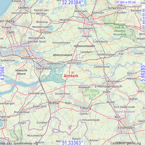
Almkerk GPS coordinates[2]
51° 46' 14.988" North, 4° 57' 34.992" East
| Map corner | latitude | longitude |
|---|---|---|
| Upper-left | 52.20384°, | 4.2566° |
| Center: | 51.77083°, | 4.95972° |
| Lower-right: | 51.33363°, | 5.66285° |
| Map W x H: | 96.8×96.8 km | = 60.1×60.1mi |
| max Lat: | 53.48025° ⇑65.9% North |
| Almkerk: | 51.77083° |
| min Lat: | ⇓34.1% South 50.76917° |
| min Long | Almkerk | max Long |
| 3.38611° | 4.95972° | 7.16528° |
| W 25.5%⇐ | ⇒74.5% E |
Elevation
Elevation of Almkerk is 3 m = 10 ft, and this is 12 m = 39 ft below average elevation for this country.
| Max E: |
203 m = 666 ft | 65.8% |
| Avg. | 15 m = 49 ft | |
| Almkerk | 3 m = 10 ft | |
Min E: |
-6 m = -20 ft | 34.2% |
See also: Netherlands elevation on elevation.city.
Geographical zone
Almkerk is located in North temperate zone (between Tropic of Cancer and the Arctic Circle). Distance of this North polar circle is 1644.8 km =1022 mi to North.| Distance of | km | miles | from Almkerk |
|---|---|---|---|
| North Pole | 4250.7 | 2641.3 | to North |
| Arctic Circle | 1644.8 | 1022 | to North |
| Tropic Cancer | 3150.5 | 1957.6 | to South |
| Equator | 5756.4 | 3576.9 | to South |


Nearby cities:
15 places around Almkerk: (largest is in red/bold)
• Andel
6.9 km =4.3 mi,  78°
78°
• Boven-Hardinxveld
7.9 km =4.9 mi,  317°
317°
• Dalem
7.2 km =4.5 mi,  28°
28°
• Eethen
7.7 km =4.8 mi,  123°
123°
• Genderen
9.6 km =6 mi,  113°
113°
• Giessen
5.3 km =3.3 mi,  66°
66°
• Gorinchem
7.4 km =4.6 mi,  6°
6°
• Meeuwen
5.8 km =3.6 mi,  142°
142°
• Poederoijen
8.5 km =5.3 mi, 78°
• Rijswijk
5.4 km =3.4 mi,  56°
56°
• Schelluinen
8.4 km =5.2 mi,  344°
344°
• Vuren
8.4 km =5.2 mi,  44°
44°
• Waspik
9.4 km =5.8 mi,  186°
186°
• Werkendam
6.3 km =3.9 mi,  314°
314°
• Woudrichem
5.7 km =3.5 mi, 30°
Sources, notices
• [Note1] Compared only with cities in Netherlands existing in our database
• [Src1] Map data: © OpenStreetMap contributors (CC-BY-SA)
• [Src2] Other city data from geonames.org with taken over terms of usage.
• [Src3] Geographical zone / Annual Mean Temperature by Robert A. Rohde @ Wikipedia
