Woudrichem geodata
Woudrichem (North Brabant) is a populated place; located in Netherlands in Europe/Amsterdam (GMT+2) time zone. With population of 14,208 people, there are 228 cities with bigger population in this country. Compared to other cities in Netherlands, 63.6% of cities are located further ↑North; 73.5% of cities are located further →East and 74.9% of cities have higher elevation than Woudrichem. Note1


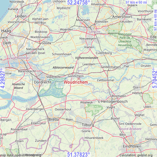
Woudrichem GPS coordinates[2]
51° 48' 54" North, 5° 0' 5.004" East
| Map corner | latitude | longitude |
|---|---|---|
| Upper-left | 52.24758°, | 4.29827° |
| Center: | 51.815°, | 5.00139° |
| Lower-right: | 51.37823°, | 5.70452° |
| Map W x H: | 96.7×96.7 km | = 60.1×60.1mi |
| max Lat: | 53.48025° ⇑63.6% North |
| Woudrichem: | 51.815° |
| min Lat: | ⇓36.4% South 50.76917° |
| min Long | Woudrichem | max Long |
| 3.38611° | 5.00139° | 7.16528° |
| W 26.5%⇐ | ⇒73.5% E |
Elevation
Elevation of Woudrichem is 2 m = 7 ft, and this is 13 m = 43 ft below average elevation for this country.
| Max E: |
203 m = 666 ft | 74.9% |
| Avg. | 15 m = 49 ft | |
| Woudrichem | 2 m = 7 ft | |
Min E: |
-6 m = -20 ft | 25.1% |
See also: Netherlands elevation on elevation.city.
Geographical zone
Woudrichem is located in North temperate zone (between Tropic of Cancer and the Arctic Circle). Distance of this North polar circle is 1639.9 km =1019 mi to North.| Distance of | km | miles | from Woudrichem |
|---|---|---|---|
| North Pole | 4245.8 | 2638.2 | to North |
| Arctic Circle | 1639.9 | 1019 | to North |
| Tropic Cancer | 3155.4 | 1960.7 | to South |
| Equator | 5761.3 | 3579.9 | to South |


Nearby cities:
15 places around Woudrichem: (largest is in red/bold)
• Almkerk
5.7 km =3.5 mi,  210°
210°
• Andel
5.3 km =3.3 mi,  131°
131°
• Arkel
5.5 km =3.4 mi,  355°
355°
• Boven-Hardinxveld
8.3 km =5.2 mi,  276°
276°
• Brakel
6.1 km =3.8 mi,  87°
87°
• Dalem
1.5 km =0.9 mi,  22°
22°
• Giessen
3.4 km =2.1 mi,  144°
144°
• Gorinchem
3.1 km =1.9 mi,  320°
320°
• Hoogblokland
6.9 km =4.3 mi,  345°
345°
• Kedichem
6 km =3.7 mi,  33°
33°
• Poederoijen
6.3 km =3.9 mi,  120°
120°
• Rijswijk
2.5 km =1.6 mi, 140°
• Schelluinen
6 km =3.7 mi,  301°
301°
• Vuren
3.3 km =2.1 mi,  69°
69°
• Werkendam
7.4 km =4.6 mi,  265°
265°
Sources, notices
• [Note1] Compared only with cities in Netherlands existing in our database
• [Src1] Map data: © OpenStreetMap contributors (CC-BY-SA)
• [Src2] Other city data from geonames.org with taken over terms of usage.
• [Src3] Geographical zone / Annual Mean Temperature by Robert A. Rohde @ Wikipedia
