Trondheim geodata
Trondheim (Trøndelag) is a seat of a second-order administrative division; located in Norway in Europe/Oslo (GMT+2) time zone. With population of 147,139 people, there are 2 cities with bigger population in this country. Compared to other cities in Norway, 76.4% of cities are located further ↓South; 56.2% of cities are located further ←West and 70.6% of cities have higher elevation than Trondheim. Note1


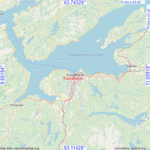
Trondheim GPS coordinates[2]
63° 25' 49.764" North, 10° 23' 42.216" East
| Map corner | latitude | longitude |
|---|---|---|
| Upper-left | 63.74326°, | 9.69194° |
| Center: | 63.43049°, | 10.39506° |
| Lower-right: | 63.11426°, | 11.09819° |
| Map W x H: | 69.9×69.9 km | = 43.4×43.4mi |
| max Lat: | 71.04137° ⇑23.6% North |
| Trondheim: | 63.43049° |
| min Lat: | ⇓76.4% South 58.0274° |
| min Long | Trondheim | max Long |
| 4.71485° | 10.39506° | 31.11066° |
| W 56.2%⇐ | ⇒43.8% E |
Elevation
Elevation of Trondheim is 18 m = 59 ft, and this is 86.2 m = 283 ft below average elevation for this country.
| Max E: |
897 m = 2943 ft | 70.6% |
| Avg. | 104.2 m = 342 ft | |
| Trondheim | 18 m = 59 ft | |
Min E: |
1 m = 3 ft | 29.4% |
See also: Trondheim elevation on elevation.city.
Geographical zone
Trondheim is located in North temperate zone (between Tropic of Cancer and the Arctic Circle). Distance of this North polar circle is 348.4 km =216.5 mi to North.| Distance of | km | miles | from Trondheim |
|---|---|---|---|
| North Pole | 2954.3 | 1835.7 | to North |
| Arctic Circle | 348.4 | 216.5 | to North |
| Tropic Cancer | 4446.9 | 2763.2 | to South |
| Equator | 7052.8 | 4382.4 | to South |


Nearby cities:
15 places around Trondheim: (largest is in red/bold)
• Børsa
19.9 km =12.4 mi,  234°
234°
• Frosta
24.6 km =15.3 mi,  44°
44°
• Hell
25.2 km =15.7 mi,  86°
86°
• Hommelvik
20 km =12.4 mi,  96°
96°
• Klæbu
15.4 km =9.6 mi,  163°
163°
• Leksvik
29.2 km =18.1 mi,  22°
22°
• Lensvik
30.7 km =19.1 mi,  287°
287°
• Malvik
14.3 km =8.9 mi, 88°
• Melhus
17.1 km =10.6 mi,  199°
199°
• Orkanger
30.4 km =18.9 mi,  243°
243°
• Rissa
27.5 km =17.1 mi,  308°
308°
• Skaun
26.2 km =16.3 mi,  220°
220°
• Stjørdal
26.3 km =16.3 mi,  80°
80°
• Stjørdalshalsen
26.7 km =16.6 mi, 80°
• Tanem
12.9 km =8 mi,  167°
167°
Sources, notices
• [Note1] Compared only with cities in Norway existing in our database
• [Src1] Map data: © OpenStreetMap contributors (CC-BY-SA)
• [Src2] Other city data from geonames.org with taken over terms of usage.
• [Src3] Geographical zone / Annual Mean Temperature by Robert A. Rohde @ Wikipedia
