Rissa geodata
Rissa (Trøndelag) is a seat of a second-order administrative division; located in Norway in Europe/Oslo (GMT+2) time zone. In our database, there are 488 cities with bigger population. Compared to other cities in Norway, 77.7% of cities are located further ↓South; 52.1% of cities are located further →East and 55.9% of cities have higher elevation than Rissa. Note1


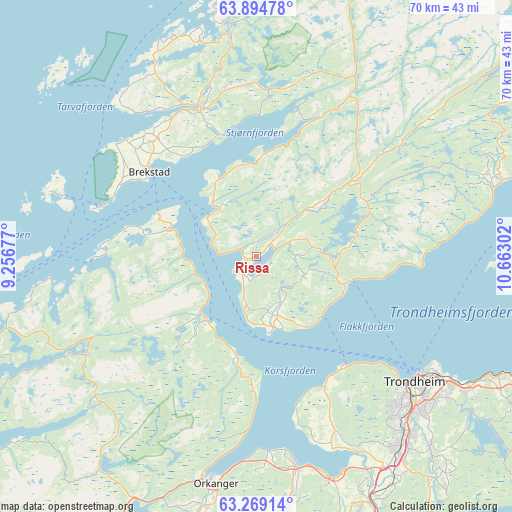
Rissa GPS coordinates[2]
63° 35' 1.248" North, 9° 57' 35.604" East
| Map corner | latitude | longitude |
|---|---|---|
| Upper-left | 63.89478°, | 9.25677° |
| Center: | 63.58368°, | 9.95989° |
| Lower-right: | 63.26914°, | 10.66302° |
| Map W x H: | 69.6×69.6 km | = 43.2×43.2mi |
| max Lat: | 71.04137° ⇑22.3% North |
| Rissa: | 63.58368° |
| min Lat: | ⇓77.7% South 58.0274° |
| min Long | Rissa | max Long |
| 4.71485° | 9.95989° | 31.11066° |
| W 47.9%⇐ | ⇒52.1% E |
Elevation
Elevation of Rissa is 33 m = 108 ft, and this is 71.2 m = 234 ft below average elevation for this country.
| Max E: |
897 m = 2943 ft | 55.9% |
| Avg. | 104.2 m = 342 ft | |
| Rissa | 33 m = 108 ft | |
Min E: |
1 m = 3 ft | 44.1% |
See also: Norway elevation on elevation.city.
Geographical zone
Rissa is located in North temperate zone (between Tropic of Cancer and the Arctic Circle). Distance of this North polar circle is 331.3 km =205.9 mi to North.| Distance of | km | miles | from Rissa |
|---|---|---|---|
| North Pole | 2937.2 | 1825.1 | to North |
| Arctic Circle | 331.3 | 205.9 | to North |
| Tropic Cancer | 4463.9 | 2773.7 | to South |
| Equator | 7069.8 | 4393 | to South |


Nearby cities:
15 places around Rissa: (largest is in red/bold)
• Botngård
21.5 km =13.4 mi,  339°
339°
• Brekstad
18.5 km =11.5 mi,  308°
308°
• Børsa
29.1 km =18.1 mi,  169°
169°
• Frosta
38.7 km =24 mi,  89°
89°
• Klæbu
41.1 km =25.5 mi,  140°
140°
• Krokstadøra
30.5 km =19 mi,  228°
228°
• Leksvik
34.2 km =21.3 mi,  73°
73°
• Lensvik
10.9 km =6.8 mi,  224°
224°
• Malvik
39.6 km =24.6 mi,  114°
114°
• Melhus
36.7 km =22.8 mi,  154°
154°
• Orkanger
31.3 km =19.4 mi,  190°
190°
• Skaun
37.2 km =23.1 mi, 172°
• Tanem
38.4 km =23.9 mi, 140°
• Trondheim
27.5 km =17.1 mi,  128°
128°
• Å i Åfjord
43.9 km =27.3 mi,  17°
17°
Sources, notices
• [Note1] Compared only with cities in Norway existing in our database
• [Src1] Map data: © OpenStreetMap contributors (CC-BY-SA)
• [Src2] Other city data from geonames.org with taken over terms of usage.
• [Src3] Geographical zone / Annual Mean Temperature by Robert A. Rohde @ Wikipedia
