Stjørdalshalsen geodata
Stjørdalshalsen (Trøndelag) is a populated place; located in Norway in Europe/Oslo (GMT+2) time zone. With population of 11,416 people, there are 42 cities with bigger population in this country. Compared to other cities in Norway, 77.4% of cities are located further ↓South; 66% of cities are located further ←West and 73.9% of cities have higher elevation than Stjørdalshalsen. Note1


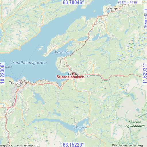
Stjørdalshalsen GPS coordinates[2]
63° 28' 5.16" North, 10° 55' 34.248" East
| Map corner | latitude | longitude |
|---|---|---|
| Upper-left | 63.78046°, | 10.22306° |
| Center: | 63.4681°, | 10.92618° |
| Lower-right: | 63.15229°, | 11.62931° |
| Map W x H: | 69.8×69.8 km | = 43.4×43.4mi |
| max Lat: | 71.04137° ⇑22.6% North |
| Stjørdalshalsen: | 63.4681° |
| min Lat: | ⇓77.4% South 58.0274° |
| min Long | Stjørdalshalse | max Long |
| 4.71485° | 10.92618° | 31.11066° |
| W 66%⇐ | ⇒34% E |
Elevation
Elevation of Stjørdalshalsen is 15 m = 49 ft, and this is 89.2 m = 293 ft below average elevation for this country.
| Max E: |
897 m = 2943 ft | 73.9% |
| Avg. | 104.2 m = 342 ft | |
| Stjørdalshalsen | 15 m = 49 ft | |
Min E: |
1 m = 3 ft | 26.1% |
See also: Norway elevation on elevation.city.
Geographical zone
Stjørdalshalsen is located in North temperate zone (between Tropic of Cancer and the Arctic Circle). Distance of this North polar circle is 344.2 km =213.9 mi to North.| Distance of | km | miles | from Stjørdalshalsen |
|---|---|---|---|
| North Pole | 2950.1 | 1833.1 | to North |
| Arctic Circle | 344.2 | 213.9 | to North |
| Tropic Cancer | 4451.1 | 2765.8 | to South |
| Equator | 7057 | 4385 | to South |


Nearby cities:
15 places around Stjørdalshalsen: (largest is in red/bold)
• Frosta
16.3 km =10.1 mi,  325°
325°
• Hegra
9.4 km =5.8 mi,  92°
92°
• Hell
2.8 km =1.7 mi,  206°
206°
• Hommelvik
9.1 km =5.7 mi,  225°
225°
• Klæbu
29.1 km =18.1 mi, 229°
• Leksvik
27.3 km =17 mi, 326°
• Levanger
36 km =22.4 mi,  30°
30°
• Malvik
12.7 km =7.9 mi,  252°
252°
• Mebonden
26.9 km =16.7 mi,  168°
168°
• Melhus
38.1 km =23.7 mi,  237°
237°
• Meråker
41 km =25.5 mi,  98°
98°
• Skogn
29.3 km =18.2 mi, 26°
• Stjørdal
0.4 km =0.2 mi,  268°
268°
• Tanem
29.1 km =18.1 mi, 234°
• Trondheim
26.7 km =16.6 mi,  260°
260°
Sources, notices
• [Note1] Compared only with cities in Norway existing in our database
• [Src1] Map data: © OpenStreetMap contributors (CC-BY-SA)
• [Src2] Other city data from geonames.org with taken over terms of usage.
• [Src3] Geographical zone / Annual Mean Temperature by Robert A. Rohde @ Wikipedia
