Langevåg geodata
Langevåg (Hordaland) is a populated place; located in Norway in Europe/Oslo (GMT+2) time zone. With population of 733 people, there are 371 cities with bigger population in this country. Compared to other cities in Norway, 75.9% of cities are located further ↑North; 95.7% of cities are located further →East and 92.1% of cities have higher elevation than Langevåg. Note1


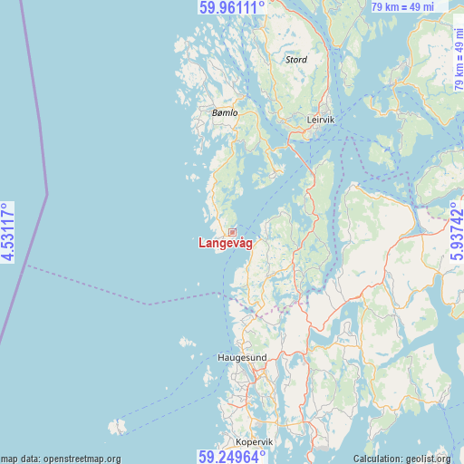
Langevåg GPS coordinates[2]
59° 36' 26.136" North, 5° 14' 3.48" East
| Map corner | latitude | longitude |
|---|---|---|
| Upper-left | 59.96111°, | 4.53117° |
| Center: | 59.60726°, | 5.2343° |
| Lower-right: | 59.24964°, | 5.93742° |
| Map W x H: | 79.1×79.1 km | = 49.2×49.2mi |
| max Lat: | 71.04137° ⇑75.9% North |
| Langevåg: | 59.60726° |
| min Lat: | ⇓24.1% South 58.0274° |
| min Long | Langevåg | max Long |
| 4.71485° | 5.2343° | 31.11066° |
| W 4.3%⇐ | ⇒95.7% E |
Elevation
Elevation of Langevåg is 3 m = 10 ft, and this is 101.2 m = 332 ft below average elevation for this country.
| Max E: |
897 m = 2943 ft | 92.1% |
| Avg. | 104.2 m = 342 ft | |
| Langevåg | 3 m = 10 ft | |
Min E: |
1 m = 3 ft | 7.9% |
See also: Norway elevation on elevation.city.
Geographical zone
Langevåg is located in North temperate zone (between Tropic of Cancer and the Arctic Circle). Distance of this North polar circle is 773.5 km =480.6 mi to North.| Distance of | km | miles | from Langevåg |
|---|---|---|---|
| North Pole | 3379.4 | 2099.9 | to North |
| Arctic Circle | 773.5 | 480.6 | to North |
| Tropic Cancer | 4021.8 | 2499 | to South |
| Equator | 6627.7 | 4118.3 | to South |


Nearby cities:
15 places around Langevåg: (largest is in red/bold)
• Aksdal
23.6 km =14.7 mi,  149°
149°
• Eike
24.4 km =15.2 mi,  162°
162°
• Haugesund
21.6 km =13.4 mi,  174°
174°
• Holme
6.4 km =4 mi,  320°
320°
• Leirvik
24.3 km =15.1 mi,  37°
37°
• Mosterhamn
13.3 km =8.3 mi, 39°
• Rubbestadneset
23.2 km =14.4 mi,  4°
4°
• Sagvåg
21.2 km =13.2 mi,  24°
24°
• Skjold
23 km =14.3 mi,  120°
120°
• Sveio
9.8 km =6.1 mi,  137°
137°
• Svortland
20.9 km =13 mi,  350°
350°
• Valvatna
20.5 km =12.7 mi,  30°
30°
• Visnes
27.9 km =17.3 mi,  179°
179°
• Vormedal
28.3 km =17.6 mi, 170°
• Ølen
32.3 km =20.1 mi,  90°
90°
Sources, notices
• [Note1] Compared only with cities in Norway existing in our database
• [Src1] Map data: © OpenStreetMap contributors (CC-BY-SA)
• [Src2] Other city data from geonames.org with taken over terms of usage.
• [Src3] Geographical zone / Annual Mean Temperature by Robert A. Rohde @ Wikipedia
