Sagvåg geodata
Sagvåg (Hordaland) is a populated place; located in Norway in Europe/Oslo (GMT+2) time zone. With population of 3,288 people, there are 123 cities with bigger population in this country. Compared to other cities in Norway, 70.7% of cities are located further ↑North; 92.1% of cities are located further →East and 50.6% of cities have lower elevation than Sagvåg. Note1


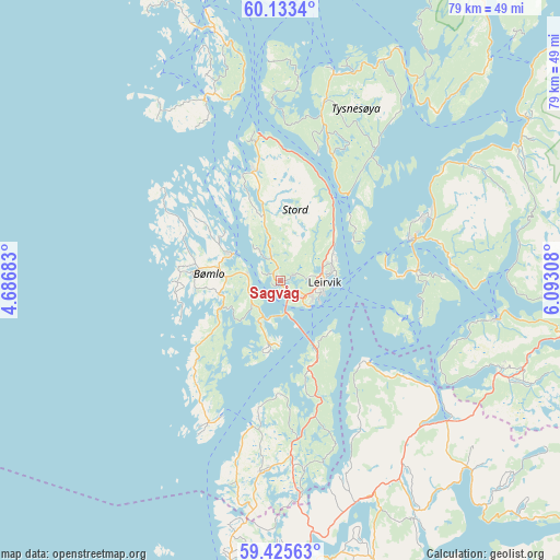
Sagvåg GPS coordinates[2]
59° 46' 53.004" North, 5° 23' 23.856" East
| Map corner | latitude | longitude |
|---|---|---|
| Upper-left | 60.1334°, | 4.68683° |
| Center: | 59.78139°, | 5.38996° |
| Lower-right: | 59.42563°, | 6.09308° |
| Map W x H: | 78.7×78.7 km | = 48.9×48.9mi |
| max Lat: | 71.04137° ⇑70.7% North |
| Sagvåg: | 59.78139° |
| min Lat: | ⇓29.3% South 58.0274° |
| min Long | Sagvåg | max Long |
| 4.71485° | 5.38996° | 31.11066° |
| W 7.9%⇐ | ⇒92.1% E |
Elevation
Elevation of Sagvåg is 43 m = 141 ft, and this is 61.2 m = 201 ft below average elevation for this country.
| Max E: |
897 m = 2943 ft | 49.4% |
| Avg. | 104.2 m = 342 ft | |
| Sagvåg | 43 m = 141 ft | |
Min E: |
1 m = 3 ft | 50.6% |
See also: Norway elevation on elevation.city.
Geographical zone
Sagvåg is located in North temperate zone (between Tropic of Cancer and the Arctic Circle). Distance of this North polar circle is 754.1 km =468.6 mi to North.| Distance of | km | miles | from Sagvåg |
|---|---|---|---|
| North Pole | 3360 | 2087.8 | to North |
| Arctic Circle | 754.1 | 468.6 | to North |
| Tropic Cancer | 4041.1 | 2511 | to South |
| Equator | 6647.1 | 4130.3 | to South |


Nearby cities:
15 places around Sagvåg: (largest is in red/bold)
• Fitjar
15.7 km =9.8 mi,  344°
344°
• Holme
19.3 km =12 mi,  221°
221°
• Langevåg
21.2 km =13.2 mi,  204°
204°
• Leirvik
6.2 km =3.9 mi,  91°
91°
• Mosterhamn
9.1 km =5.7 mi,  181°
181°
• Rubbestadneset
7.8 km =4.8 mi,  299°
299°
• Skånevik
31.1 km =19.3 mi,  99°
99°
• Sveio
26.7 km =16.6 mi, 184°
• Svortland
12.2 km =7.6 mi,  275°
275°
• Sæbøvik
17.9 km =11.1 mi, 85°
• Uggdal
25.9 km =16.1 mi,  17°
17°
• Uskedalen
31.4 km =19.5 mi,  57°
57°
• Valvatna
2.2 km =1.4 mi,  137°
137°
• Våge
30.1 km =18.7 mi,  14°
14°
• Ølen
30.6 km =19 mi,  130°
130°
Sources, notices
• [Note1] Compared only with cities in Norway existing in our database
• [Src1] Map data: © OpenStreetMap contributors (CC-BY-SA)
• [Src2] Other city data from geonames.org with taken over terms of usage.
• [Src3] Geographical zone / Annual Mean Temperature by Robert A. Rohde @ Wikipedia
