Svortland geodata
Svortland (Hordaland) is a seat of a second-order administrative division; located in Norway in Europe/Oslo (GMT+2) time zone. In our database, there are 488 cities with bigger population. Compared to other cities in Norway, 70.4% of cities are located further ↑North; 96.8% of cities are located further →East and 62.5% of cities have higher elevation than Svortland. Note1


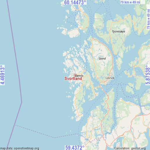
Svortland GPS coordinates[2]
59° 47' 34.224" North, 5° 10' 20.136" East
| Map corner | latitude | longitude |
|---|---|---|
| Upper-left | 60.14473°, | 4.46913° |
| Center: | 59.79284°, | 5.17226° |
| Lower-right: | 59.4372°, | 5.87538° |
| Map W x H: | 78.7×78.7 km | = 48.9×48.9mi |
| max Lat: | 71.04137° ⇑70.4% North |
| Svortland: | 59.79284° |
| min Lat: | ⇓29.6% South 58.0274° |
| min Long | Svortland | max Long |
| 4.71485° | 5.17226° | 31.11066° |
| W 3.2%⇐ | ⇒96.8% E |
Elevation
Elevation of Svortland is 25 m = 82 ft, and this is 79.2 m = 260 ft below average elevation for this country.
| Max E: |
897 m = 2943 ft | 62.5% |
| Avg. | 104.2 m = 342 ft | |
| Svortland | 25 m = 82 ft | |
Min E: |
1 m = 3 ft | 37.5% |
See also: Norway elevation on elevation.city.
Geographical zone
Svortland is located in North temperate zone (between Tropic of Cancer and the Arctic Circle). Distance of this North polar circle is 752.8 km =467.8 mi to North.| Distance of | km | miles | from Svortland |
|---|---|---|---|
| North Pole | 3358.7 | 2087 | to North |
| Arctic Circle | 752.8 | 467.8 | to North |
| Tropic Cancer | 4042.4 | 2511.8 | to South |
| Equator | 6648.3 | 4131.1 | to South |


Nearby cities:
15 places around Svortland: (largest is in red/bold)
• Fitjar
16.1 km =10 mi,  30°
30°
• Holme
15.7 km =9.8 mi,  182°
182°
• Langevåg
20.9 km =13 mi,  170°
170°
• Leirvik
18.4 km =11.4 mi,  94°
94°
• Mosterhamn
15.9 km =9.9 mi,  131°
131°
• Rubbestadneset
5.9 km =3.7 mi,  64°
64°
• Sagvåg
12.2 km =7.6 mi,  95°
95°
• Skjold
39.8 km =24.7 mi,  144°
144°
• Storebø
33.7 km =20.9 mi,  5°
5°
• Sveio
29.7 km =18.5 mi,  160°
160°
• Sæbøvik
30.1 km =18.7 mi, 89°
• Uggdal
30.8 km =19.1 mi,  40°
40°
• Valvatna
14 km =8.7 mi, 102°
• Våge
34 km =21.1 mi, 35°
• Ølen
41.4 km =25.7 mi,  120°
120°
Sources, notices
• [Note1] Compared only with cities in Norway existing in our database
• [Src1] Map data: © OpenStreetMap contributors (CC-BY-SA)
• [Src2] Other city data from geonames.org with taken over terms of usage.
• [Src3] Geographical zone / Annual Mean Temperature by Robert A. Rohde @ Wikipedia
