Wellington geodata
Wellington is a capital of a political entity; located in New Zealand in Pacific/Auckland (GMT+13) time zone. With population of 381,900 people, there is 1 city with bigger population in this country. Compared to other cities in New Zealand, 65.7% of cities are located further ↑North; 58% of cities are located further ←West and 51.7% of cities have higher elevation than Wellington. Note1


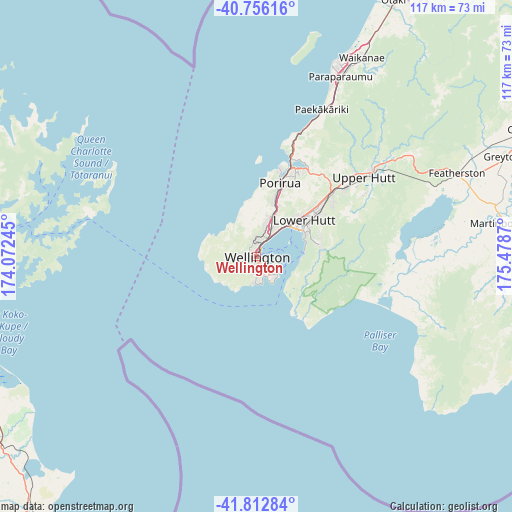
Wellington GPS coordinates[2]
41° 17' 11.904" South, 174° 46' 32.052" East
| Map corner | latitude | longitude |
|---|---|---|
| Upper-left | -40.75616°, | 174.07245° |
| Center: | -41.28664°, | 174.77557° |
| Lower-right: | -41.81284°, | 175.4787° |
| Map W x H: | 117.5×117.5 km | = 73×73mi |
| max Lat: | -34.99604° ⇑65.7% North |
| Wellington: | -41.28664° |
| min Lat: | ⇓34.3% South -46.6° |
| min Long | Wellington | max Long |
| -176.55973° | 174.77557° | 178.33333° |
| W 58%⇐ | ⇒42% E |
Elevation
Elevation of Wellington is 31 m = 102 ft, and this is 53.4 m = 175 ft below average elevation for this country.
| Max E: |
819 m = 2687 ft | 51.7% |
| Avg. | 84.4 m = 277 ft | |
| Wellington | 31 m = 102 ft | |
Min E: |
3 m = 10 ft | 48.3% |
See also: Wellington elevation on elevation.city.
Geographical zone
Wellington is located in South temperate zone (between Tropic of Capricorn and the Antarctic Circle). Distance of this Southern Tropic circle is 1984.7 km =1233.2 mi to North.| Distance of | km | miles | from Wellington |
|---|---|---|---|
| Equator | 4590.6 | 2852.5 | to North |
| Tropic Capricorn | 1984.7 | 1233.2 | to North |
| Antarctic Circle | 2810.5 | 1746.4 | to South |
| South Pole | 5416.4 | 3365.6 | to South |


Nearby cities:
15 places around Wellington: (largest is in red/bold)
• Blenheim
73.2 km =45.5 mi,  249°
249°
• Brooklyn
2.4 km =1.5 mi,  206°
206°
• Kelburn
0.8 km =0.5 mi,  296°
296°
• Khandallah
4.9 km =3 mi,  18°
18°
• Lower Hutt
14.1 km =8.8 mi,  56°
56°
• Ohariu
9.7 km =6 mi,  355°
355°
• Otaki
66.6 km =41.4 mi,  28°
28°
• Paraparaumu
45.8 km =28.5 mi, 26°
• Petone
10.2 km =6.3 mi,  50°
50°
• Picton
64.1 km =39.8 mi,  269°
269°
• Porirua
18.1 km =11.2 mi, 20°
• Seddon
71.5 km =44.4 mi,  233°
233°
• Te Horo
60.6 km =37.7 mi, 26°
• Upper Hutt
28.3 km =17.6 mi, 54°
• Waipawa
63.3 km =39.3 mi,  102°
102°
Sources, notices
• [Note1] Compared only with cities in New Zealand existing in our database
• [Src1] Map data: © OpenStreetMap contributors (CC-BY-SA)
• [Src2] Other city data from geonames.org with taken over terms of usage.
• [Src3] Geographical zone / Annual Mean Temperature by Robert A. Rohde @ Wikipedia
