Porirua geodata
Porirua (Wellington) is a populated place; located in New Zealand in Pacific/Auckland (GMT+12) time zone. With population of 50,914 people, there are 16 cities with bigger population in this country. Compared to other cities in New Zealand, 60.9% of cities are located further ↑North; 59.9% of cities are located further ←West and 65.2% of cities have lower elevation than Porirua. Note1


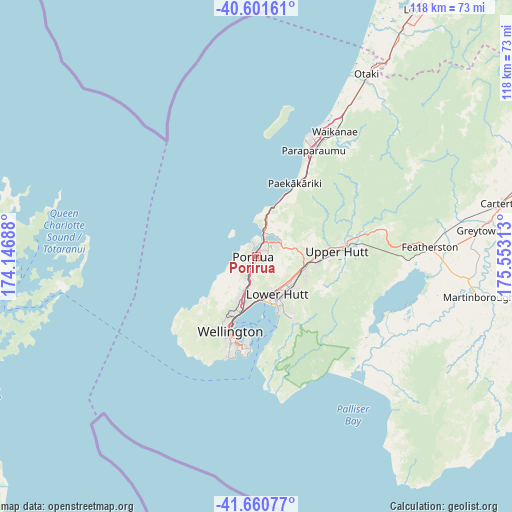
Porirua GPS coordinates[2]
41° 7' 59.988" South, 174° 51' 0" East
| Map corner | latitude | longitude |
|---|---|---|
| Upper-left | -40.60161°, | 174.14688° |
| Center: | -41.13333°, | 174.85° |
| Lower-right: | -41.66077°, | 175.55313° |
| Map W x H: | 117.8×117.8 km | = 73.2×73.2mi |
| max Lat: | -34.99604° ⇑60.9% North |
| Porirua: | -41.13333° |
| min Lat: | ⇓39.1% South -46.6° |
| min Long | Porirua | max Long |
| -176.55973° | 174.85° | 178.33333° |
| W 59.9%⇐ | ⇒40.1% E |
Elevation
Elevation of Porirua is 58 m = 190 ft, and this is 26.4 m = 87 ft below average elevation for this country.
| Max E: |
819 m = 2687 ft | 34.8% |
| Avg. | 84.4 m = 277 ft | |
| Porirua | 58 m = 190 ft | |
Min E: |
3 m = 10 ft | 65.2% |
See also: Porirua elevation on elevation.city.
Geographical zone
Porirua is located in South temperate zone (between Tropic of Capricorn and the Antarctic Circle). Distance of this Southern Tropic circle is 1967.7 km =1222.7 mi to North.| Distance of | km | miles | from Porirua |
|---|---|---|---|
| Equator | 4573.6 | 2841.9 | to North |
| Tropic Capricorn | 1967.7 | 1222.7 | to North |
| Antarctic Circle | 2827.6 | 1757 | to South |
| South Pole | 5433.5 | 3376.2 | to South |


Nearby cities:
15 places around Porirua: (largest is in red/bold)
• Brooklyn
20.5 km =12.7 mi,  200°
200°
• Kelburn
18.1 km =11.2 mi, 202°
• Khandallah
13.3 km =8.3 mi, 200°
• Levin
66.1 km =41.1 mi,  32°
32°
• Lower Hutt
10.8 km =6.7 mi,  148°
148°
• Manakau
55.6 km =34.5 mi, 33°
• Masterton
70.4 km =43.7 mi,  74°
74°
• Ohariu
10.2 km =6.3 mi,  223°
223°
• Otaki
48.7 km =30.3 mi, 31°
• Paraparaumu
27.9 km =17.3 mi, 30°
• Petone
10.7 km =6.6 mi,  170°
170°
• Te Horo
42.6 km =26.5 mi, 29°
• Upper Hutt
16.8 km =10.4 mi,  91°
91°
• Waipawa
63.7 km =39.6 mi,  119°
119°
• Wellington
18.1 km =11.2 mi, 200°
Sources, notices
• [Note1] Compared only with cities in New Zealand existing in our database
• [Src1] Map data: © OpenStreetMap contributors (CC-BY-SA)
• [Src2] Other city data from geonames.org with taken over terms of usage.
• [Src3] Geographical zone / Annual Mean Temperature by Robert A. Rohde @ Wikipedia
