Waipawa geodata
Waipawa (Wellington) is a populated place; located in New Zealand in Pacific/Auckland (GMT+12) time zone. With population of 1,899 people, there are 104 cities with bigger population in this country. Compared to other cities in New Zealand, 68.6% of cities are located further ↑North; 76.8% of cities are located further ←West and 90.3% of cities have lower elevation than Waipawa. Note1


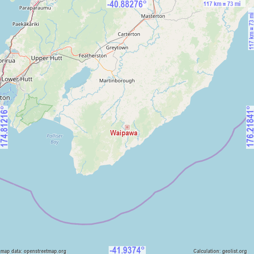
Waipawa GPS coordinates[2]
41° 24' 43.992" South, 175° 30' 55.008" East
| Map corner | latitude | longitude |
|---|---|---|
| Upper-left | -40.88276°, | 174.81216° |
| Center: | -41.41222°, | 175.51528° |
| Lower-right: | -41.9374°, | 176.21841° |
| Map W x H: | 117.3×117.3 km | = 72.9×72.9mi |
| max Lat: | -34.99604° ⇑68.6% North |
| Waipawa: | -41.41222° |
| min Lat: | ⇓31.4% South -46.6° |
| min Long | Waipawa | max Long |
| -176.55973° | 175.51528° | 178.33333° |
| W 76.8%⇐ | ⇒23.2% E |
Elevation
Elevation of Waipawa is 238 m = 781 ft, and this is 153.6 m = 504 ft above average elevation for this country.
| Max E: |
819 m = 2687 ft | 9.7% |
| Waipawa | 238 m 781 ft | |
| Avg. | 84.4 m = 277 ft | |
Min E: |
3 m = 10 ft | 90.3% |
See also: New Zealand elevation on elevation.city.
Geographical zone
Waipawa is located in South temperate zone (between Tropic of Capricorn and the Antarctic Circle). Distance of this Southern Tropic circle is 1998.7 km =1241.9 mi to North.| Distance of | km | miles | from Waipawa |
|---|---|---|---|
| Equator | 4604.6 | 2861.2 | to North |
| Tropic Capricorn | 1998.7 | 1241.9 | to North |
| Antarctic Circle | 2796.6 | 1737.7 | to South |
| South Pole | 5402.5 | 3357 | to South |


Nearby cities:
15 places around Waipawa: (largest is in red/bold)
• Brooklyn
63.9 km =39.7 mi,  280°
280°
• Castlepoint
81.8 km =50.8 mi,  45°
45°
• Kelburn
64.1 km =39.8 mi, 282°
• Khandallah
63 km =39.1 mi,  287°
287°
• Lower Hutt
54.5 km =33.9 mi, 293°
• Manakau
81.3 km =50.5 mi,  342°
342°
• Masterton
51.7 km =32.1 mi,  13°
13°
• Ohariu
66.8 km =41.5 mi, 290°
• Otaki
78.9 km =49 mi, 337°
• Paraparaumu
69.1 km =42.9 mi,  322°
322°
• Petone
57.6 km =35.8 mi, 290°
• Porirua
63.7 km =39.6 mi,  299°
299°
• Te Horo
76.4 km =47.5 mi,  332°
332°
• Upper Hutt
49.4 km =30.7 mi,  308°
308°
• Wellington
63.3 km =39.3 mi, 282°
Sources, notices
• [Note1] Compared only with cities in New Zealand existing in our database
• [Src1] Map data: © OpenStreetMap contributors (CC-BY-SA)
• [Src2] Other city data from geonames.org with taken over terms of usage.
• [Src3] Geographical zone / Annual Mean Temperature by Robert A. Rohde @ Wikipedia
