Wallacetown geodata
Wallacetown (Southland) is a populated place; located in New Zealand in Pacific/Auckland (GMT+12) time zone. With population of 638 people, there are 176 cities with bigger population in this country. Compared to other cities in New Zealand, 98.1% of cities are located further ↑North; 97.6% of cities are located further →East and 89.9% of cities have higher elevation than Wallacetown. Note1


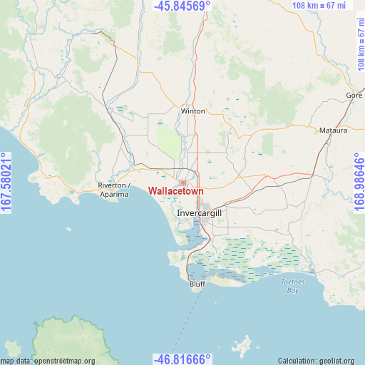
Wallacetown GPS coordinates[2]
46° 19' 59.988" South, 168° 16' 59.988" East
| Map corner | latitude | longitude |
|---|---|---|
| Upper-left | -45.84569°, | 167.58021° |
| Center: | -46.33333°, | 168.28333° |
| Lower-right: | -46.81666°, | 168.98646° |
| Map W x H: | 108×108 km | = 67.1×67.1mi |
| max Lat: | -34.99604° ⇑98.1% North |
| Wallacetown: | -46.33333° |
| min Lat: | ⇓1.9% South -46.6° |
| min Long | Wallacetown | max Long |
| -176.55973° | 168.28333° | 178.33333° |
| W 2.4%⇐ | ⇒97.6% E |
Elevation
Elevation of Wallacetown is 8 m = 26 ft, and this is 76.4 m = 251 ft below average elevation for this country.
| Max E: |
819 m = 2687 ft | 89.9% |
| Avg. | 84.4 m = 277 ft | |
| Wallacetown | 8 m = 26 ft | |
Min E: |
3 m = 10 ft | 10.1% |
See also: New Zealand elevation on elevation.city.
Geographical zone
Wallacetown is located in South temperate zone (between Tropic of Capricorn and the Antarctic Circle). Distance of this South polar circle is 2249.4 km =1397.7 mi to South.| Distance of | km | miles | from Wallacetown |
|---|---|---|---|
| Equator | 5151.8 | 3201.2 | to North |
| Tropic Capricorn | 2545.9 | 1581.9 | to North |
| Antarctic Circle | 2249.4 | 1397.7 | to South |
| South Pole | 4855.3 | 3016.9 | to South |


Nearby cities:
15 places around Wallacetown: (largest is in red/bold)
• Balclutha
113.2 km =70.3 mi,  84°
84°
• Bluff
29.9 km =18.6 mi,  172°
172°
• Edendale
38.4 km =23.9 mi,  87°
87°
• Gore
56.9 km =35.4 mi,  63°
63°
• Invercargill
9 km =5.6 mi,  145°
145°
• Kaitangata
120.5 km =74.9 mi, 86°
• Kingston
116.2 km =72.2 mi,  16°
16°
• Otautau
29.8 km =18.5 mi,  313°
313°
• Papatowai
94.4 km =58.7 mi,  105°
105°
• Riverton
20.6 km =12.8 mi,  264°
264°
• Roxburgh
118.9 km =73.9 mi,  42°
42°
• Te Anau
111 km =69 mi,  336°
336°
• Tuatapere
51.2 km =31.8 mi,  295°
295°
• Winton
20.7 km =12.9 mi,  10°
10°
• Wyndham
43.5 km =27 mi, 90°
Sources, notices
• [Note1] Compared only with cities in New Zealand existing in our database
• [Src1] Map data: © OpenStreetMap contributors (CC-BY-SA)
• [Src2] Other city data from geonames.org with taken over terms of usage.
• [Src3] Geographical zone / Annual Mean Temperature by Robert A. Rohde @ Wikipedia
