Invercargill geodata
Invercargill (Southland) is a seat of a first-order administrative division; located in New Zealand in Pacific/Auckland (GMT+12) time zone. With population of 47,287 people, there are 19 cities with bigger population in this country. Compared to other cities in New Zealand, 99% of cities are located further ↑North; 96.1% of cities are located further →East and 97.1% of cities have higher elevation than Invercargill. Note1


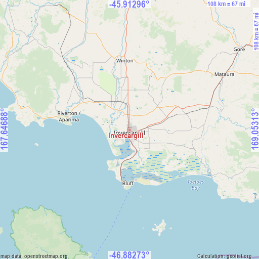
Invercargill GPS coordinates[2]
46° 24' 0" South, 168° 21' 0" East
| Map corner | latitude | longitude |
|---|---|---|
| Upper-left | -45.91296°, | 167.64688° |
| Center: | -46.4°, | 168.35° |
| Lower-right: | -46.88273°, | 169.05313° |
| Map W x H: | 107.8×107.8 km | = 67×67mi |
| max Lat: | -34.99604° ⇑99% North |
| Invercargill: | -46.4° |
| min Lat: | ⇓1% South -46.6° |
| min Long | Invercargill | max Long |
| -176.55973° | 168.35° | 178.33333° |
| W 3.9%⇐ | ⇒96.1% E |
Elevation
Elevation of Invercargill is 6 m = 20 ft, and this is 78.4 m = 257 ft below average elevation for this country.
| Max E: |
819 m = 2687 ft | 97.1% |
| Avg. | 84.4 m = 277 ft | |
| Invercargill | 6 m = 20 ft | |
Min E: |
3 m = 10 ft | 2.9% |
See also: Invercargill elevation on elevation.city.
Geographical zone
Invercargill is located in South temperate zone (between Tropic of Capricorn and the Antarctic Circle). Distance of this South polar circle is 2242 km =1393.1 mi to South.| Distance of | km | miles | from Invercargill |
|---|---|---|---|
| Equator | 5159.2 | 3205.8 | to North |
| Tropic Capricorn | 2553.3 | 1586.5 | to North |
| Antarctic Circle | 2242 | 1393.1 | to South |
| South Pole | 4847.9 | 3012.3 | to South |


Nearby cities:
15 places around Invercargill: (largest is in red/bold)
• Balclutha
109.1 km =67.8 mi,  80°
80°
• Bluff
22.3 km =13.9 mi,  183°
183°
• Edendale
34.5 km =21.4 mi,  74°
74°
• Gore
56.3 km =35 mi,  54°
54°
• Kaitangata
116 km =72.1 mi, 83°
• Kingston
122 km =75.8 mi,  13°
13°
• Otautau
38.7 km =24 mi,  315°
315°
• Papatowai
87.6 km =54.4 mi,  101°
101°
• Riverton
26.2 km =16.3 mi,  282°
282°
• Roxburgh
121.2 km =75.3 mi,  37°
37°
• Te Anau
119.8 km =74.4 mi,  335°
335°
• Tuatapere
59.2 km =36.8 mi,  300°
300°
• Wallacetown
9 km =5.6 mi,  325°
325°
• Winton
27.8 km =17.3 mi,  357°
357°
• Wyndham
39.1 km =24.3 mi, 79°
Sources, notices
• [Note1] Compared only with cities in New Zealand existing in our database
• [Src1] Map data: © OpenStreetMap contributors (CC-BY-SA)
• [Src2] Other city data from geonames.org with taken over terms of usage.
• [Src3] Geographical zone / Annual Mean Temperature by Robert A. Rohde @ Wikipedia
