Te Anau geodata
Te Anau (Southland) is a populated place; located in New Zealand in Pacific/Auckland (GMT+12) time zone. With population of 2,074 people, there are 98 cities with bigger population in this country. Compared to other cities in New Zealand, 90.8% of cities are located further ↑North; 99% of cities are located further →East and 88.9% of cities have lower elevation than Te Anau. Note1


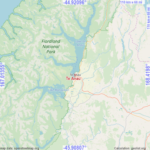
Te Anau GPS coordinates[2]
45° 25' 0.012" South, 167° 43' 0.012" East
| Map corner | latitude | longitude |
|---|---|---|
| Upper-left | -44.92096°, | 167.01355° |
| Center: | -45.41667°, | 167.71667° |
| Lower-right: | -45.90807°, | 168.4198° |
| Map W x H: | 109.8×109.8 km | = 68.2×68.2mi |
| max Lat: | -34.99604° ⇑90.8% North |
| Te Anau: | -45.41667° |
| min Lat: | ⇓9.2% South -46.6° |
| min Long | Te Anau | max Long |
| -176.55973° | 167.71667° | 178.33333° |
| W 1%⇐ | ⇒99% E |
Elevation
Elevation of Te Anau is 215 m = 705 ft, and this is 130.6 m = 428 ft above average elevation for this country.
| Max E: |
819 m = 2687 ft | 11.1% |
| Te Anau | 215 m 705 ft | |
| Avg. | 84.4 m = 277 ft | |
Min E: |
3 m = 10 ft | 88.9% |
See also: New Zealand elevation on elevation.city.
Geographical zone
Te Anau is located in South temperate zone (between Tropic of Capricorn and the Antarctic Circle). Distance of this South polar circle is 2351.3 km =1461 mi to South.| Distance of | km | miles | from Te Anau |
|---|---|---|---|
| Equator | 5049.9 | 3137.9 | to North |
| Tropic Capricorn | 2443.9 | 1518.6 | to North |
| Antarctic Circle | 2351.3 | 1461 | to South |
| South Pole | 4957.2 | 3080.3 | to South |


Nearby cities:
15 places around Te Anau: (largest is in red/bold)
• Arrowtown
100.9 km =62.7 mi,  58°
58°
• Clyde
127.6 km =79.3 mi,  78°
78°
• Cromwell
123.5 km =76.7 mi,  70°
70°
• Edendale
129.7 km =80.6 mi,  140°
140°
• Gore
122 km =75.8 mi,  128°
128°
• Invercargill
119.8 km =74.4 mi,  155°
155°
• Kingston
78.5 km =48.8 mi, 83°
• Otautau
84.4 km =52.4 mi, 164°
• Queenstown
85.6 km =53.2 mi, 59°
• Riverton
106.3 km =66.1 mi,  167°
167°
• Roxburgh
125.3 km =77.9 mi,  96°
96°
• Tuatapere
79.7 km =49.5 mi,  181°
181°
• Wallacetown
111 km =69 mi, 156°
• Winton
94.5 km =58.7 mi,  149°
149°
• Wyndham
134.5 km =83.6 mi, 139°
Sources, notices
• [Note1] Compared only with cities in New Zealand existing in our database
• [Src1] Map data: © OpenStreetMap contributors (CC-BY-SA)
• [Src2] Other city data from geonames.org with taken over terms of usage.
• [Src3] Geographical zone / Annual Mean Temperature by Robert A. Rohde @ Wikipedia
