Richmond geodata
Richmond (Tasman) is a seat of a first-order administrative division; located in New Zealand in Pacific/Auckland (GMT+13) time zone. With population of 14,000 people, there are 36 cities with bigger population in this country. Compared to other cities in New Zealand, 67.1% of cities are located further ↑North; 66.7% of cities are located further →East and 81.6% of cities have higher elevation than Richmond. Note1


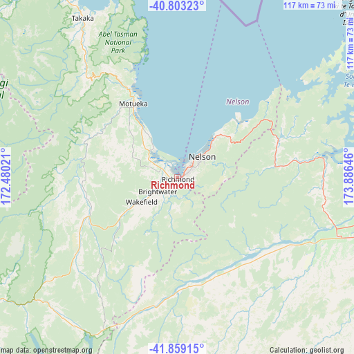
Richmond GPS coordinates[2]
41° 19' 59.988" South, 173° 10' 59.988" East
| Map corner | latitude | longitude |
|---|---|---|
| Upper-left | -40.80323°, | 172.48021° |
| Center: | -41.33333°, | 173.18333° |
| Lower-right: | -41.85915°, | 173.88646° |
| Map W x H: | 117.4×117.4 km | = 72.9×72.9mi |
| max Lat: | -34.99604° ⇑67.1% North |
| Richmond: | -41.33333° |
| min Lat: | ⇓32.9% South -46.6° |
| min Long | Richmond | max Long |
| -176.55973° | 173.18333° | 178.33333° |
| W 33.3%⇐ | ⇒66.7% E |
Elevation
Elevation of Richmond is 10 m = 33 ft, and this is 74.4 m = 244 ft below average elevation for this country.
| Max E: |
819 m = 2687 ft | 81.6% |
| Avg. | 84.4 m = 277 ft | |
| Richmond | 10 m = 33 ft | |
Min E: |
3 m = 10 ft | 18.4% |
See also: New Zealand elevation on elevation.city.
Geographical zone
Richmond is located in South temperate zone (between Tropic of Capricorn and the Antarctic Circle). Distance of this Southern Tropic circle is 1989.9 km =1236.5 mi to North.| Distance of | km | miles | from Richmond |
|---|---|---|---|
| Equator | 4595.8 | 2855.7 | to North |
| Tropic Capricorn | 1989.9 | 1236.5 | to North |
| Antarctic Circle | 2805.3 | 1743.1 | to South |
| South Pole | 5411.2 | 3362.4 | to South |


Nearby cities:
15 places around Richmond: (largest is in red/bold)
• Blenheim
67.3 km =41.8 mi,  107°
107°
• Brightwater
7.9 km =4.9 mi,  225°
225°
• Brooklyn
131.9 km =82 mi,  88°
88°
• Havelock
49 km =30.4 mi,  83°
83°
• Kaikoura
127.4 km =79.2 mi,  161°
161°
• Kelburn
132.4 km =82.3 mi, 87°
• Mapua
11.6 km =7.2 mi,  323°
323°
• Motueka
26.2 km =16.3 mi,  327°
327°
• Murchison
87.7 km =54.5 mi, 233°
• Nelson
10.9 km =6.8 mi,  50°
50°
• Picton
69 km =42.9 mi, 86°
• Riwaka
31.7 km =19.7 mi, 331°
• Seddon
83.6 km =51.9 mi,  116°
116°
• Takaka
62.6 km =38.9 mi, 329°
• Wakefield
13.4 km =8.3 mi,  236°
236°
Sources, notices
• [Note1] Compared only with cities in New Zealand existing in our database
• [Src1] Map data: © OpenStreetMap contributors (CC-BY-SA)
• [Src2] Other city data from geonames.org with taken over terms of usage.
• [Src3] Geographical zone / Annual Mean Temperature by Robert A. Rohde @ Wikipedia
