Nelson geodata
Nelson is a seat of a first-order administrative division; located in New Zealand in Pacific/Auckland (GMT+12) time zone. With population of 59,200 people, there are 13 cities with bigger population in this country. Compared to other cities in New Zealand, 64.3% of cities are located further ↑North; 65.7% of cities are located further →East and 78.3% of cities have higher elevation than Nelson. Note1


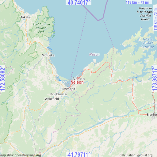
Nelson GPS coordinates[2]
41° 16' 14.808" South, 173° 17' 2.544" East
| Map corner | latitude | longitude |
|---|---|---|
| Upper-left | -40.74017°, | 172.58092° |
| Center: | -41.27078°, | 173.28404° |
| Lower-right: | -41.79711°, | 173.98717° |
| Map W x H: | 117.5×117.5 km | = 73×73mi |
| max Lat: | -34.99604° ⇑64.3% North |
| Nelson: | -41.27078° |
| min Lat: | ⇓35.7% South -46.6° |
| min Long | Nelson | max Long |
| -176.55973° | 173.28404° | 178.33333° |
| W 34.3%⇐ | ⇒65.7% E |
Elevation
Elevation of Nelson is 11 m = 36 ft, and this is 73.4 m = 241 ft below average elevation for this country.
| Max E: |
819 m = 2687 ft | 78.3% |
| Avg. | 84.4 m = 277 ft | |
| Nelson | 11 m = 36 ft | |
Min E: |
3 m = 10 ft | 21.7% |
See also: Nelson elevation on elevation.city.
Geographical zone
Nelson is located in South temperate zone (between Tropic of Capricorn and the Antarctic Circle). Distance of this Southern Tropic circle is 1983 km =1232.2 mi to North.| Distance of | km | miles | from Nelson |
|---|---|---|---|
| Equator | 4588.9 | 2851.4 | to North |
| Tropic Capricorn | 1983 | 1232.2 | to North |
| Antarctic Circle | 2812.3 | 1747.5 | to South |
| South Pole | 5418.2 | 3366.7 | to South |


Nearby cities:
15 places around Nelson: (largest is in red/bold)
• Blenheim
62.1 km =38.6 mi,  116°
116°
• Brightwater
18.8 km =11.7 mi,  228°
228°
• Brooklyn
123.6 km =76.8 mi,  91°
91°
• Havelock
40.4 km =25.1 mi, 91°
• Kelburn
123.9 km =77 mi, 90°
• Mapua
15.6 km =9.7 mi,  278°
278°
• Motueka
27.1 km =16.8 mi,  304°
304°
• Murchison
98.6 km =61.3 mi, 233°
• Ohariu
124.2 km =77.2 mi, 86°
• Picton
60.5 km =37.6 mi, 92°
• Richmond
10.9 km =6.8 mi, 230°
• Riwaka
31.6 km =19.6 mi,  311°
311°
• Seddon
79.8 km =49.6 mi, 123°
• Takaka
61.9 km =38.5 mi,  319°
319°
• Wakefield
24.3 km =15.1 mi, 233°
Sources, notices
• [Note1] Compared only with cities in New Zealand existing in our database
• [Src1] Map data: © OpenStreetMap contributors (CC-BY-SA)
• [Src2] Other city data from geonames.org with taken over terms of usage.
• [Src3] Geographical zone / Annual Mean Temperature by Robert A. Rohde @ Wikipedia
