Motueka geodata
Motueka (Tasman) is a populated place; located in New Zealand in Pacific/Auckland (GMT+13) time zone. With population of 7,485 people, there are 47 cities with bigger population in this country. Compared to other cities in New Zealand, 60.9% of cities are located further ↑North; 69.1% of cities are located further →East and 100% of cities have higher elevation than Motueka. Note1


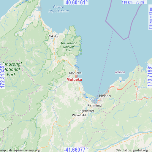
Motueka GPS coordinates[2]
41° 7' 59.988" South, 173° 1' 0.012" East
| Map corner | latitude | longitude |
|---|---|---|
| Upper-left | -40.60161°, | 172.31355° |
| Center: | -41.13333°, | 173.01667° |
| Lower-right: | -41.66077°, | 173.7198° |
| Map W x H: | 117.8×117.8 km | = 73.2×73.2mi |
| max Lat: | -34.99604° ⇑60.9% North |
| Motueka: | -41.13333° |
| min Lat: | ⇓39.1% South -46.6° |
| min Long | Motueka | max Long |
| -176.55973° | 173.01667° | 178.33333° |
| W 30.9%⇐ | ⇒69.1% E |
Elevation
Elevation of Motueka is 3 m = 10 ft, and this is 81.4 m = 267 ft below average elevation for this country.
| Max E: |
819 m = 2687 ft | 100% |
| Avg. | 84.4 m = 277 ft | |
| Motueka | 3 m = 10 ft | |
Min E: |
3 m = 10 ft | 0% |
See also: New Zealand elevation on elevation.city.
Geographical zone
Motueka is located in South temperate zone (between Tropic of Capricorn and the Antarctic Circle). Distance of this Southern Tropic circle is 1967.7 km =1222.7 mi to North.| Distance of | km | miles | from Motueka |
|---|---|---|---|
| Equator | 4573.6 | 2841.9 | to North |
| Tropic Capricorn | 1967.7 | 1222.7 | to North |
| Antarctic Circle | 2827.6 | 1757 | to South |
| South Pole | 5433.5 | 3376.2 | to South |


Nearby cities:
15 places around Motueka: (largest is in red/bold)
• Blenheim
89 km =55.3 mi,  118°
118°
• Brightwater
29 km =18 mi,  163°
163°
• Havelock
64.9 km =40.3 mi,  104°
104°
• Mapua
14.7 km =9.1 mi,  151°
151°
• Murchison
93.5 km =58.1 mi,  217°
217°
• Nelson
27.1 km =16.8 mi, 124°
• Ohariu
146.7 km =91.2 mi,  92°
92°
• Picton
84.7 km =52.6 mi, 101°
• Reefton
145.2 km =90.2 mi, 221°
• Richmond
26.2 km =16.3 mi, 147°
• Riwaka
5.7 km =3.5 mi,  345°
345°
• Seddon
106.9 km =66.4 mi, 123°
• Takaka
36.4 km =22.6 mi,  330°
330°
• Wakefield
29.8 km =18.5 mi,  174°
174°
• Westport
136.4 km =84.8 mi,  239°
239°
Sources, notices
• [Note1] Compared only with cities in New Zealand existing in our database
• [Src1] Map data: © OpenStreetMap contributors (CC-BY-SA)
• [Src2] Other city data from geonames.org with taken over terms of usage.
• [Src3] Geographical zone / Annual Mean Temperature by Robert A. Rohde @ Wikipedia
