Masterton geodata
Masterton (Wellington) is a populated place; located in New Zealand in Pacific/Auckland (GMT+12) time zone. With population of 20,698 people, there are 30 cities with bigger population in this country. Compared to other cities in New Zealand, 59.4% of cities are located further ↑North; 79.7% of cities are located further ←West and 76.8% of cities have lower elevation than Masterton. Note1


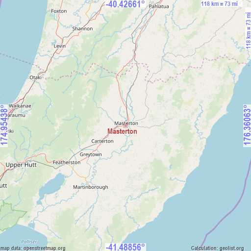
Masterton GPS coordinates[2]
40° 57' 34.992" South, 175° 39' 27" East
| Map corner | latitude | longitude |
|---|---|---|
| Upper-left | -40.42661°, | 174.95438° |
| Center: | -40.95972°, | 175.6575° |
| Lower-right: | -41.48856°, | 176.36063° |
| Map W x H: | 118.1×118.1 km | = 73.4×73.4mi |
| max Lat: | -34.99604° ⇑59.4% North |
| Masterton: | -40.95972° |
| min Lat: | ⇓40.6% South -46.6° |
| min Long | Masterton | max Long |
| -176.55973° | 175.6575° | 178.33333° |
| W 79.7%⇐ | ⇒20.3% E |
Elevation
Elevation of Masterton is 103 m = 338 ft, and this is 18.6 m = 61 ft above average elevation for this country.
| Max E: |
819 m = 2687 ft | 23.2% |
| Masterton | 103 m 338 ft | |
| Avg. | 84.4 m = 277 ft | |
Min E: |
3 m = 10 ft | 76.8% |
See also: New Zealand elevation on elevation.city.
Geographical zone
Masterton is located in South temperate zone (between Tropic of Capricorn and the Antarctic Circle). Distance of this Southern Tropic circle is 1948.4 km =1210.7 mi to North.| Distance of | km | miles | from Masterton |
|---|---|---|---|
| Equator | 4554.3 | 2829.9 | to North |
| Tropic Capricorn | 1948.4 | 1210.7 | to North |
| Antarctic Circle | 2846.9 | 1769 | to South |
| South Pole | 5452.8 | 3388.2 | to South |


Nearby cities:
15 places around Masterton: (largest is in red/bold)
• Castlepoint
47.4 km =29.5 mi,  81°
81°
• Foxton
62.6 km =38.9 mi,  331°
331°
• Himatangi
68.6 km =42.6 mi,  335°
335°
• Levin
48.5 km =30.1 mi,  318°
318°
• Linton Military Camp
62.2 km =38.6 mi,  354°
354°
• Lower Hutt
68.3 km =42.4 mi,  245°
245°
• Manakau
45.9 km =28.5 mi,  306°
306°
• Otaki
48.2 km =30 mi,  297°
297°
• Palmerston North
67.2 km =41.8 mi,  356°
356°
• Paraparaumu
54 km =33.6 mi,  275°
275°
• Porirua
70.4 km =43.7 mi, 254°
• Te Horo
50.1 km =31.1 mi,  290°
290°
• Tokomaru
55.5 km =34.5 mi, 347°
• Upper Hutt
54.7 km =34 mi, 248°
• Waipawa
51.7 km =32.1 mi,  193°
193°
Sources, notices
• [Note1] Compared only with cities in New Zealand existing in our database
• [Src1] Map data: © OpenStreetMap contributors (CC-BY-SA)
• [Src2] Other city data from geonames.org with taken over terms of usage.
• [Src3] Geographical zone / Annual Mean Temperature by Robert A. Rohde @ Wikipedia
