Thames geodata
Thames (Waikato) is a populated place; located in New Zealand in Pacific/Auckland (GMT+12) time zone. With population of 7,136 people, there are 48 cities with bigger population in this country. Compared to other cities in New Zealand, 78.3% of cities are located further ↓South; 77.8% of cities are located further ←West and 97.1% of cities have higher elevation than Thames. Note1


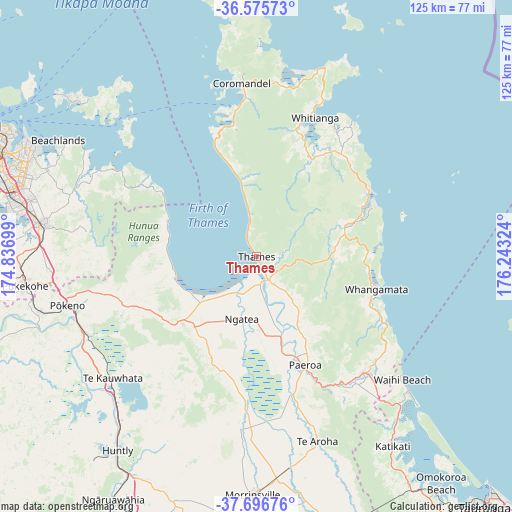
Thames GPS coordinates[2]
37° 8' 17.952" South, 175° 32' 24.396" East
| Map corner | latitude | longitude |
|---|---|---|
| Upper-left | -36.57573°, | 174.83699° |
| Center: | -37.13832°, | 175.54011° |
| Lower-right: | -37.69676°, | 176.24324° |
| Map W x H: | 124.6×124.6 km | = 77.4×77.4mi |
| max Lat: | -34.99604° ⇑21.7% North |
| Thames: | -37.13832° |
| min Lat: | ⇓78.3% South -46.6° |
| min Long | Thames | max Long |
| -176.55973° | 175.54011° | 178.33333° |
| W 77.8%⇐ | ⇒22.2% E |
Elevation
Elevation of Thames is 6 m = 20 ft, and this is 78.4 m = 257 ft below average elevation for this country.
| Max E: |
819 m = 2687 ft | 97.1% |
| Avg. | 84.4 m = 277 ft | |
| Thames | 6 m = 20 ft | |
Min E: |
3 m = 10 ft | 2.9% |
See also: New Zealand elevation on elevation.city.
Geographical zone
Thames is located in South temperate zone (between Tropic of Capricorn and the Antarctic Circle). Distance of this Southern Tropic circle is 1523.5 km =946.7 mi to North.| Distance of | km | miles | from Thames |
|---|---|---|---|
| Equator | 4129.4 | 2565.9 | to North |
| Tropic Capricorn | 1523.5 | 946.7 | to North |
| Antarctic Circle | 3271.8 | 2033 | to South |
| South Pole | 5877.7 | 3652.2 | to South |


Nearby cities:
15 places around Thames: (largest is in red/bold)
• Athenree
49.4 km =30.7 mi,  137°
137°
• Bombay
49.4 km =30.7 mi,  266°
266°
• Coromandel
42.1 km =26.2 mi,  354°
354°
• Kerepehi
18 km =11.2 mi,  181°
181°
• Ngatea
16.5 km =10.3 mi,  192°
192°
• Paeroa
27.8 km =17.3 mi,  156°
156°
• Pauanui
32 km =19.9 mi,  64°
64°
• Pukekohe East
52.7 km =32.7 mi,  262°
262°
• Red Hill
51.3 km =31.9 mi,  279°
279°
• Tairua
30.6 km =19 mi, 63°
• Te Kauwhata
45.1 km =28 mi,  229°
229°
• Waihi
37.6 km =23.4 mi, 136°
• Waihi Beach
45.4 km =28.2 mi,  129°
129°
• Whangamata
29.7 km =18.5 mi,  103°
103°
• Whitianga
36.8 km =22.9 mi,  22°
22°
Sources, notices
• [Note1] Compared only with cities in New Zealand existing in our database
• [Src1] Map data: © OpenStreetMap contributors (CC-BY-SA)
• [Src2] Other city data from geonames.org with taken over terms of usage.
• [Src3] Geographical zone / Annual Mean Temperature by Robert A. Rohde @ Wikipedia
