Whangamata geodata
Whangamata (Waikato) is a populated place; located in New Zealand in Pacific/Auckland (GMT+12) time zone. With population of 4,253 people, there are 68 cities with bigger population in this country. Compared to other cities in New Zealand, 76.8% of cities are located further ↓South; 84.5% of cities are located further ←West and 93.7% of cities have higher elevation than Whangamata. Note1


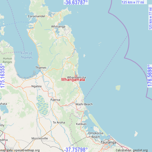
Whangamata GPS coordinates[2]
37° 12' 0" South, 175° 52' 0.012" East
| Map corner | latitude | longitude |
|---|---|---|
| Upper-left | -36.63787°, | 175.16355° |
| Center: | -37.2°, | 175.86667° |
| Lower-right: | -37.75798°, | 176.5698° |
| Map W x H: | 124.5×124.5 km | = 77.4×77.4mi |
| max Lat: | -34.99604° ⇑23.2% North |
| Whangamata: | -37.2° |
| min Lat: | ⇓76.8% South -46.6° |
| min Long | Whangamata | max Long |
| -176.55973° | 175.86667° | 178.33333° |
| W 84.5%⇐ | ⇒15.5% E |
Elevation
Elevation of Whangamata is 7 m = 23 ft, and this is 77.4 m = 254 ft below average elevation for this country.
| Max E: |
819 m = 2687 ft | 93.7% |
| Avg. | 84.4 m = 277 ft | |
| Whangamata | 7 m = 23 ft | |
Min E: |
3 m = 10 ft | 6.3% |
See also: New Zealand elevation on elevation.city.
Geographical zone
Whangamata is located in South temperate zone (between Tropic of Capricorn and the Antarctic Circle). Distance of this Southern Tropic circle is 1530.3 km =950.9 mi to North.| Distance of | km | miles | from Whangamata |
|---|---|---|---|
| Equator | 4136.3 | 2570.2 | to North |
| Tropic Capricorn | 1530.3 | 950.9 | to North |
| Antarctic Circle | 3264.9 | 2028.7 | to South |
| South Pole | 5870.8 | 3647.9 | to South |


Nearby cities:
15 places around Whangamata: (largest is in red/bold)
• Athenree
30 km =18.6 mi,  171°
171°
• Coromandel
58.9 km =36.6 mi,  326°
326°
• Katikati
39.2 km =24.4 mi, 173°
• Kerepehi
31.5 km =19.6 mi,  249°
249°
• Ngatea
33.8 km =21 mi, 254°
• Paeroa
25.6 km =15.9 mi,  223°
223°
• Pauanui
20.4 km =12.7 mi,  0°
0°
• Tairua
20.4 km =12.7 mi,  355°
355°
• Tauranga
60.2 km =37.4 mi,  153°
153°
• Te Kauwhata
67.2 km =41.8 mi, 250°
• Thames
29.7 km =18.5 mi,  283°
283°
• Waharoa
63.6 km =39.5 mi,  187°
187°
• Waihi
20.6 km =12.8 mi, 188°
• Waihi Beach
23 km =14.3 mi, 165°
• Whitianga
43.4 km =27 mi,  340°
340°
Sources, notices
• [Note1] Compared only with cities in New Zealand existing in our database
• [Src1] Map data: © OpenStreetMap contributors (CC-BY-SA)
• [Src2] Other city data from geonames.org with taken over terms of usage.
• [Src3] Geographical zone / Annual Mean Temperature by Robert A. Rohde @ Wikipedia
