Villa Alondra geodata
Villa Alondra (Colón) is a populated place; located in Panama in America/Panama (GMT-5) time zone. With population of 705 people, there are 353 cities with bigger population in this country. Compared to other cities in Panama, 97.1% of cities are located further ↓South; 80.9% of cities are located further ←West and 83.8% of cities have higher elevation than Villa Alondra. Note1


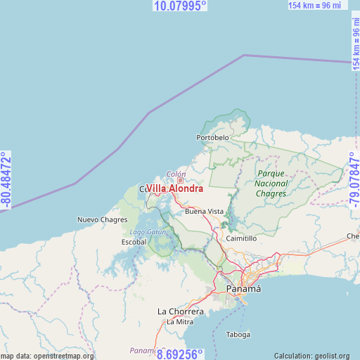
Villa Alondra GPS coordinates[2]
9° 23' 13.02" North, 79° 46' 53.724" West
| Map corner | latitude | longitude |
|---|---|---|
| Upper-left | 10.07995°, | -80.48472° |
| Center: | 9.38695°, | -79.78159° |
| Lower-right: | 8.69256°, | -79.07847° |
| Map W x H: | 154.3×154.3 km | = 95.9×95.9mi |
| max Lat: | 9.60898° ⇑2.9% North |
| Villa Alondra: | 9.38695° |
| min Lat: | ⇓97.1% South 7.26534° |
| min Long | Villa Alondra | max Long |
| -82.91275° | -79.78159° | -77.38965° |
| W 80.9%⇐ | ⇒19.1% E |
Elevation
Elevation of Villa Alondra is 19 m = 62 ft, and this is 153.1 m = 502 ft below average elevation for this country.
| Max E: |
2103 m = 6900 ft | 83.8% |
| Avg. | 172.1 m = 565 ft | |
| Villa Alondra | 19 m = 62 ft | |
Min E: |
-1 m = -3 ft | 16.2% |
See also: Panama elevation on elevation.city.
Geographical zone
Villa Alondra is located in North Torrid zone (between Equator and Tropic of Cancer). Distance of Equator is 1043.7 km =648.5 mi to South.| Distance of | km | miles | from Villa Alondra |
|---|---|---|---|
| North Pole | 8963.3 | 5569.5 | to North |
| Arctic Circle | 6357.4 | 3950.3 | to North |
| Tropic Cancer | 1562.2 | 970.7 | to North |
| Equator | 1043.7 | 648.5 | to South |


Nearby cities:
15 places around Villa Alondra: (largest is in red/bold)
• Buena Vista
15.8 km =9.8 mi,  143°
143°
• Cativá
6.2 km =3.9 mi,  243°
243°
• Colón
13.5 km =8.4 mi,  254°
254°
• Cristóbal
14 km =8.7 mi, 254°
• Gatún
10.9 km =6.8 mi,  174°
174°
• Las Margaritas
13.7 km =8.5 mi, 240°
• María Chiquita
6.6 km =4.1 mi,  26°
26°
• Nueva Providencia
14.2 km =8.8 mi,  195°
195°
• Panama City
13.4 km =8.3 mi, 244°
• Puerto Pilón
2.9 km =1.8 mi,  205°
205°
• Quebrada Bonita Adentro
13 km =8.1 mi, 140°
• Río Alejandro
1.9 km =1.2 mi, 202°
• Río Rita
9.4 km =5.8 mi,  187°
187°
• Sabanitas
5.8 km =3.6 mi, 211°
• Santa Rita Arriba
6.4 km =4 mi, 191°
Sources, notices
• [Note1] Compared only with cities in Panama existing in our database
• [Src1] Map data: © OpenStreetMap contributors (CC-BY-SA)
• [Src2] Other city data from geonames.org with taken over terms of usage.
• [Src3] Geographical zone / Annual Mean Temperature by Robert A. Rohde @ Wikipedia
