Gatún geodata
Gatún (Colón) is a populated place; located in Panama in America/Panama (GMT-5) time zone. With population of 1,553 people, there are 151 cities with bigger population in this country. Compared to other cities in Panama, 94.5% of cities are located further ↓South; 81.1% of cities are located further ←West and 73.6% of cities have higher elevation than Gatún. Note1


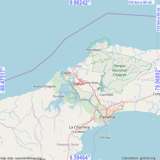
Gatún GPS coordinates[2]
9° 17' 21.192" North, 79° 46' 19.344" West
| Map corner | latitude | longitude |
|---|---|---|
| Upper-left | 9.98242°, | -80.47517° |
| Center: | 9.28922°, | -79.77204° |
| Lower-right: | 8.59464°, | -79.06892° |
| Map W x H: | 154.3×154.3 km | = 95.9×95.9mi |
| max Lat: | 9.60898° ⇑5.5% North |
| Gatún: | 9.28922° |
| min Lat: | ⇓94.5% South 7.26534° |
| min Long | Gatún | max Long |
| -82.91275° | -79.77204° | -77.38965° |
| W 81.1%⇐ | ⇒18.9% E |
Elevation
Elevation of Gatún is 32 m = 105 ft, and this is 140.1 m = 460 ft below average elevation for this country.
| Max E: |
2103 m = 6900 ft | 73.6% |
| Avg. | 172.1 m = 565 ft | |
| Gatún | 32 m = 105 ft | |
Min E: |
-1 m = -3 ft | 26.4% |
See also: Panama elevation on elevation.city.
Geographical zone
Gatún is located in North Torrid zone (between Equator and Tropic of Cancer). Distance of Equator is 1032.9 km =641.8 mi to South.| Distance of | km | miles | from Gatún |
|---|---|---|---|
| North Pole | 8974.2 | 5576.3 | to North |
| Arctic Circle | 6368.3 | 3957.1 | to North |
| Tropic Cancer | 1573.1 | 977.5 | to North |
| Equator | 1032.9 | 641.8 | to South |


Nearby cities:
15 places around Gatún: (largest is in red/bold)
• Buena Vista
8.6 km =5.3 mi,  101°
101°
• Cativá
10.5 km =6.5 mi,  320°
320°
• El Giral
10 km =6.2 mi,  119°
119°
• El Valle de la Unión
13.6 km =8.5 mi, 115°
• Las Margaritas
13.6 km =8.5 mi,  287°
287°
• Nueva Providencia
5.6 km =3.5 mi,  238°
238°
• Palenque
13.6 km =8.5 mi,  132°
132°
• Puerto Pilón
8.5 km =5.3 mi,  344°
344°
• Quebrada Bonita Adentro
7.3 km =4.5 mi,  83°
83°
• Río Alejandro
9.3 km =5.8 mi,  349°
349°
• Río Duque
10.8 km =6.7 mi,  109°
109°
• Río Rita
2.7 km =1.7 mi,  304°
304°
• Sabanitas
7.2 km =4.5 mi,  325°
325°
• Santa Rita Arriba
5.1 km =3.2 mi, 332°
• Villa Alondra
10.9 km =6.8 mi, 354°
Sources, notices
• [Note1] Compared only with cities in Panama existing in our database
• [Src1] Map data: © OpenStreetMap contributors (CC-BY-SA)
• [Src2] Other city data from geonames.org with taken over terms of usage.
• [Src3] Geographical zone / Annual Mean Temperature by Robert A. Rohde @ Wikipedia
