Cativá geodata
Cativá (Colón) is a seat of a third-order administrative division; located in Panama in America/Panama (GMT-5) time zone. With population of 29,607 people, there are 13 cities with bigger population in this country. Compared to other cities in Panama, 96.5% of cities are located further ↓South; 78.8% of cities are located further ←West and 90.4% of cities have higher elevation than Cativá. Note1


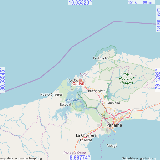
Cativá GPS coordinates[2]
9° 21' 43.848" North, 79° 49' 56.352" West
| Map corner | latitude | longitude |
|---|---|---|
| Upper-left | 10.05523°, | -80.53545° |
| Center: | 9.36218°, | -79.83232° |
| Lower-right: | 8.66774°, | -79.1292° |
| Map W x H: | 154.3×154.3 km | = 95.9×95.9mi |
| max Lat: | 9.60898° ⇑3.5% North |
| Cativá: | 9.36218° |
| min Lat: | ⇓96.5% South 7.26534° |
| min Long | Cativá | max Long |
| -82.91275° | -79.83232° | -77.38965° |
| W 78.8%⇐ | ⇒21.2% E |
Elevation
Elevation of Cativá is 12 m = 39 ft, and this is 160.1 m = 525 ft below average elevation for this country.
| Max E: |
2103 m = 6900 ft | 90.4% |
| Avg. | 172.1 m = 565 ft | |
| Cativá | 12 m = 39 ft | |
Min E: |
-1 m = -3 ft | 9.6% |
See also: Panama elevation on elevation.city.
Geographical zone
Cativá is located in North Torrid zone (between Equator and Tropic of Cancer). Distance of Equator is 1041 km =646.8 mi to South.| Distance of | km | miles | from Cativá |
|---|---|---|---|
| North Pole | 8966.1 | 5571.3 | to North |
| Arctic Circle | 6360.2 | 3952 | to North |
| Tropic Cancer | 1564.9 | 972.4 | to North |
| Equator | 1041 | 646.8 | to South |


Nearby cities:
15 places around Cativá: (largest is in red/bold)
• Buena Vista
18 km =11.2 mi,  123°
123°
• Colón
7.5 km =4.7 mi,  263°
263°
• Cristóbal
8 km =5 mi, 262°
• Gatún
10.5 km =6.5 mi,  140°
140°
• Las Margaritas
7.5 km =4.7 mi,  237°
237°
• María Chiquita
12.1 km =7.5 mi,  44°
44°
• Nueva Providencia
11.1 km =6.9 mi,  170°
170°
• Panama City
7.2 km =4.5 mi, 244°
• Puerto Pilón
4.3 km =2.7 mi,  88°
88°
• Quebrada Bonita Adentro
15.7 km =9.8 mi, 117°
• Río Alejandro
5 km =3.1 mi,  77°
77°
• Río Rita
7.9 km =4.9 mi,  146°
146°
• Sabanitas
3.3 km =2.1 mi,  131°
131°
• Santa Rita Arriba
5.5 km =3.4 mi, 129°
• Villa Alondra
6.2 km =3.9 mi,  63°
63°
Sources, notices
• [Note1] Compared only with cities in Panama existing in our database
• [Src1] Map data: © OpenStreetMap contributors (CC-BY-SA)
• [Src2] Other city data from geonames.org with taken over terms of usage.
• [Src3] Geographical zone / Annual Mean Temperature by Robert A. Rohde @ Wikipedia
