San José geodata
San José (Panamá Oeste) is a populated place; located in Panama in America/Panama (GMT-5) time zone. With population of 3,982 people, there are 77 cities with bigger population in this country. Compared to other cities in Panama, 80.6% of cities are located further ↓South; 81.7% of cities are located further ←West and 82.5% of cities have higher elevation than San José. Note1


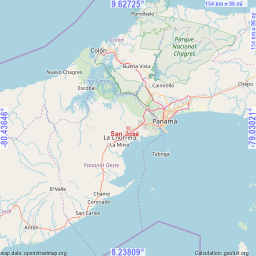
San José GPS coordinates[2]
8° 55' 59.988" North, 79° 43' 59.988" West
| Map corner | latitude | longitude |
|---|---|---|
| Upper-left | 9.62725°, | -80.43646° |
| Center: | 8.93333°, | -79.73333° |
| Lower-right: | 8.23809°, | -79.03021° |
| Map W x H: | 154.5×154.5 km | = 96×96mi |
| max Lat: | 9.60898° ⇑19.4% North |
| San José: | 8.93333° |
| min Lat: | ⇓80.6% South 7.26534° |
| min Long | San José | max Long |
| -82.91275° | -79.73333° | -77.38965° |
| W 81.7%⇐ | ⇒18.3% E |
Elevation
Elevation of San José is 20 m = 66 ft, and this is 152.1 m = 499 ft below average elevation for this country.
| Max E: |
2103 m = 6900 ft | 82.5% |
| Avg. | 172.1 m = 565 ft | |
| San José | 20 m = 66 ft | |
Min E: |
-1 m = -3 ft | 17.5% |
See also: Panama elevation on elevation.city.
Geographical zone
San José is located in North Torrid zone (between Equator and Tropic of Cancer). Distance of Equator is 993.3 km =617.2 mi to South.| Distance of | km | miles | from San José |
|---|---|---|---|
| North Pole | 9013.8 | 5600.9 | to North |
| Arctic Circle | 6407.9 | 3981.7 | to North |
| Tropic Cancer | 1612.6 | 1002 | to North |
| Equator | 993.3 | 617.2 | to South |


Nearby cities:
15 places around San José: (largest is in red/bold)
• Altos de San Francisco
10.1 km =6.3 mi,  218°
218°
• Arraiján
8.3 km =5.2 mi,  75°
75°
• Cerro El Castillo
6.7 km =4.2 mi,  62°
62°
• El Coco
10.5 km =6.5 mi,  227°
227°
• Hato Montaña
1.7 km =1.1 mi,  202°
202°
• La Chorrera
8.1 km =5 mi, 222°
• Monte Claro
7.2 km =4.5 mi,  94°
94°
• Nuevo Arraiján
1.8 km =1.1 mi,  123°
123°
• Nuevo Emperador
7.7 km =4.8 mi,  1°
1°
• Nuevo Guararé
1.8 km =1.1 mi, 90°
• Puerto Caimito
7.3 km =4.5 mi,  163°
163°
• Río Congo
4.8 km =3 mi,  320°
320°
• Río Potrero
4.8 km =3 mi,  48°
48°
• San Vicente de Bique
7 km =4.3 mi,  110°
110°
• Vista Alegre
3.4 km =2.1 mi,  100°
100°
Sources, notices
• [Note1] Compared only with cities in Panama existing in our database
• [Src1] Map data: © OpenStreetMap contributors (CC-BY-SA)
• [Src2] Other city data from geonames.org with taken over terms of usage.
• [Src3] Geographical zone / Annual Mean Temperature by Robert A. Rohde @ Wikipedia
