El Coco geodata
El Coco (Panamá Oeste) is a seat of a third-order administrative division; located in Panama in America/Panama (GMT-5) time zone. With population of 11,935 people, there are 33 cities with bigger population in this country. Compared to other cities in Panama, 78% of cities are located further ↓South; 79.7% of cities are located further ←West and 57.3% of cities have lower elevation than El Coco. Note1


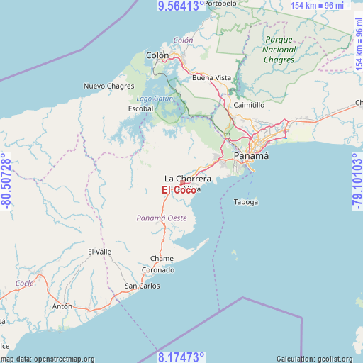
El Coco GPS coordinates[2]
8° 52' 12.324" North, 79° 48' 14.94" West
| Map corner | latitude | longitude |
|---|---|---|
| Upper-left | 9.56413°, | -80.50728° |
| Center: | 8.87009°, | -79.80415° |
| Lower-right: | 8.17473°, | -79.10103° |
| Map W x H: | 154.5×154.5 km | = 96×96mi |
| max Lat: | 9.60898° ⇑22% North |
| El Coco: | 8.87009° |
| min Lat: | ⇓78% South 7.26534° |
| min Long | El Coco | max Long |
| -82.91275° | -79.80415° | -77.38965° |
| W 79.7%⇐ | ⇒20.3% E |
Elevation
Elevation of El Coco is 93 m = 305 ft, and this is 79.1 m = 260 ft below average elevation for this country.
| Max E: |
2103 m = 6900 ft | 42.7% |
| Avg. | 172.1 m = 565 ft | |
| El Coco | 93 m = 305 ft | |
Min E: |
-1 m = -3 ft | 57.3% |
See also: Panama elevation on elevation.city.
Geographical zone
El Coco is located in North Torrid zone (between Equator and Tropic of Cancer). Distance of Equator is 986.3 km =612.9 mi to South.| Distance of | km | miles | from El Coco |
|---|---|---|---|
| North Pole | 9020.8 | 5605.3 | to North |
| Arctic Circle | 6414.9 | 3986 | to North |
| Tropic Cancer | 1619.7 | 1006.4 | to North |
| Equator | 986.3 | 612.9 | to South |


Nearby cities:
15 places around El Coco: (largest is in red/bold)
• Alto del Espino
5.5 km =3.4 mi,  235°
235°
• Altos de San Francisco
1.8 km =1.1 mi,  121°
121°
• El Espino
6.1 km =3.8 mi,  234°
234°
• Guadalupe
2 km =1.2 mi,  212°
212°
• Hato Montaña
9 km =5.6 mi,  52°
52°
• La Chorrera
2.6 km =1.6 mi,  63°
63°
• La Herradura
2.4 km =1.5 mi,  179°
179°
• La Mitra
3.8 km =2.4 mi,  149°
149°
• La Pesa
3 km =1.9 mi,  224°
224°
• La Pita
7.6 km =4.7 mi, 221°
• Llano Largo
4 km =2.5 mi,  185°
185°
• Playa Leona
10.1 km =6.3 mi,  161°
161°
• Potrero Grande
2.9 km =1.8 mi,  293°
293°
• Puerto Caimito
9.9 km =6.2 mi,  89°
89°
• Santa Rita
8.4 km =5.2 mi,  259°
259°
Sources, notices
• [Note1] Compared only with cities in Panama existing in our database
• [Src1] Map data: © OpenStreetMap contributors (CC-BY-SA)
• [Src2] Other city data from geonames.org with taken over terms of usage.
• [Src3] Geographical zone / Annual Mean Temperature by Robert A. Rohde @ Wikipedia
