Chota geodata
Chota (Cajamarca) is a seat of a third-order administrative division; located in Peru in America/Lima (GMT-5) time zone. With population of 14,240 people, there are 113 cities with bigger population in this country. Compared to other cities in Peru, 84.1% of cities are located further ↓South; 87.1% of cities are located further →East and 61.1% of cities have higher elevation than Chota. Note1


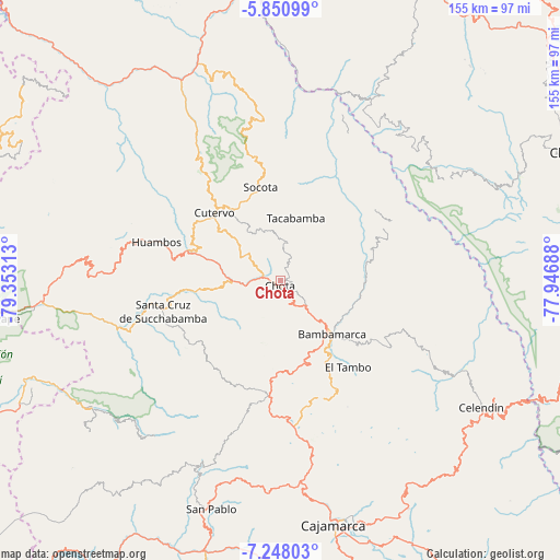
Chota GPS coordinates[2]
6° 33' 0" South, 78° 39' 0" West
| Map corner | latitude | longitude |
|---|---|---|
| Upper-left | -5.85099°, | -79.35313° |
| Center: | -6.55°, | -78.65° |
| Lower-right: | -7.24803°, | -77.94688° |
| Map W x H: | 155.3×155.3 km | = 96.5×96.5mi |
| max Lat: | -0.96667° ⇑15.9% North |
| Chota: | -6.55° |
| min Lat: | ⇓84.1% South -18.01465° |
| min Long | Chota | max Long |
| -81.30472° | -78.65° | -69.04167° |
| W 12.9%⇐ | ⇒87.1% E |
Elevation
Elevation of Chota is 2390 m = 7841 ft, and this is 71.3 m = 234 ft above average elevation for this country.
| Max E: |
5022 m = 16476 ft | 61.1% |
| Chota | 2390 m 7841 ft | |
| Avg. | 2318.7 m = 7607 ft | |
Min E: |
1 m = 3 ft | 38.9% |
See also: Peru elevation on elevation.city.
Geographical zone
Chota is located in South Torrid zone (between Equator and Tropic of Capricorn). Distance of Equator is 728.3 km =452.5 mi to North.| Distance of | km | miles | from Chota |
|---|---|---|---|
| Equator | 728.3 | 452.5 | to North |
| Tropic Capricorn | 1877.6 | 1166.7 | to South |
| Antarctic Circle | 6672.9 | 4146.3 | to South |
| South Pole | 9278.8 | 5765.6 | to South |


Nearby cities:
15 places around Chota: (largest is in red/bold)
• Bambamarca
19.6 km =12.2 mi,  139°
139°
• Chalamarca
21.1 km =13.1 mi,  71°
71°
• Chiguirip
17.5 km =10.9 mi,  328°
328°
• Choropampa
35.5 km =22.1 mi, 69°
• Chugur
17 km =10.6 mi,  220°
220°
• Cochabamba
28.6 km =17.8 mi,  285°
285°
• Cutervo
30.1 km =18.7 mi,  312°
312°
• Hualgayoc
24.4 km =15.2 mi,  171°
171°
• Huambos
36.2 km =22.5 mi,  284°
284°
• Lajas
9.4 km =5.8 mi,  258°
258°
• Paccha
26.2 km =16.3 mi,  77°
77°
• Sexi
44.4 km =27.6 mi,  268°
268°
• Socota
29.3 km =18.2 mi,  341°
341°
• Tacabamba
18.9 km =11.7 mi,  11°
11°
• Uticyacu
19 km =11.8 mi,  240°
240°
Sources, notices
• [Note1] Compared only with cities in Peru existing in our database
• [Src1] Map data: © OpenStreetMap contributors (CC-BY-SA)
• [Src2] Other city data from geonames.org with taken over terms of usage.
• [Src3] Geographical zone / Annual Mean Temperature by Robert A. Rohde @ Wikipedia
