Tacabamba geodata
Tacabamba (Cajamarca) is a seat of a third-order administrative division; located in Peru in America/Lima (GMT-5) time zone. In our database, there are 305 cities with bigger population. Compared to other cities in Peru, 86.4% of cities are located further ↓South; 86.8% of cities are located further →East and 62.6% of cities have higher elevation than Tacabamba. Note1


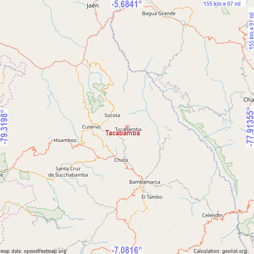
Tacabamba GPS coordinates[2]
6° 22' 59.988" South, 78° 37' 0.012" West
| Map corner | latitude | longitude |
|---|---|---|
| Upper-left | -5.6841°, | -79.3198° |
| Center: | -6.38333°, | -78.61667° |
| Lower-right: | -7.0816°, | -77.91355° |
| Map W x H: | 155.4×155.4 km | = 96.6×96.6mi |
| max Lat: | -0.96667° ⇑13.6% North |
| Tacabamba: | -6.38333° |
| min Lat: | ⇓86.4% South -18.01465° |
| min Long | Tacabamba | max Long |
| -81.30472° | -78.61667° | -69.04167° |
| W 13.2%⇐ | ⇒86.8% E |
Elevation
Elevation of Tacabamba is 2275 m = 7464 ft, and this is 43.7 m = 143 ft below average elevation for this country.
| Max E: |
5022 m = 16476 ft | 62.6% |
| Avg. | 2318.7 m = 7607 ft | |
| Tacabamba | 2275 m = 7464 ft | |
Min E: |
1 m = 3 ft | 37.4% |
See also: Peru elevation on elevation.city.
Geographical zone
Tacabamba is located in South Torrid zone (between Equator and Tropic of Capricorn). Distance of Equator is 709.8 km =441 mi to North.| Distance of | km | miles | from Tacabamba |
|---|---|---|---|
| Equator | 709.8 | 441 | to North |
| Tropic Capricorn | 1896.2 | 1178.2 | to South |
| Antarctic Circle | 6691.4 | 4157.8 | to South |
| South Pole | 9297.3 | 5777.1 | to South |


Nearby cities:
15 places around Tacabamba: (largest is in red/bold)
• Bambamarca
34.6 km =21.5 mi,  164°
164°
• Chalamarca
20.3 km =12.6 mi,  126°
126°
• Chiguirip
13.4 km =8.3 mi,  253°
253°
• Choropampa
30.1 km =18.7 mi,  101°
101°
• Chota
18.9 km =11.7 mi,  191°
191°
• Chugur
34.8 km =21.6 mi,  205°
205°
• Cochabamba
33.2 km =20.6 mi, 250°
• Cujillo
31 km =19.3 mi,  17°
17°
• Cutervo
25.8 km =16 mi,  274°
274°
• Huambos
39.8 km =24.7 mi,  256°
256°
• Lajas
24.1 km =15 mi, 212°
• Lonya Grande
38.6 km =24 mi,  33°
33°
• Paccha
25.3 km =15.7 mi,  120°
120°
• Socota
15.9 km =9.9 mi,  305°
305°
• Uticyacu
34.4 km =21.4 mi,  216°
216°
Sources, notices
• [Note1] Compared only with cities in Peru existing in our database
• [Src1] Map data: © OpenStreetMap contributors (CC-BY-SA)
• [Src2] Other city data from geonames.org with taken over terms of usage.
• [Src3] Geographical zone / Annual Mean Temperature by Robert A. Rohde @ Wikipedia
