Pomacocha geodata
Pomacocha (Huancavelica) is a seat of a third-order administrative division; located in Peru in America/Lima (GMT-5) time zone. In our database, there are 305 cities with bigger population. Compared to other cities in Peru, 59.8% of cities are located further ↑North; 62% of cities are located further ←West and 79.1% of cities have lower elevation than Pomacocha. Note1


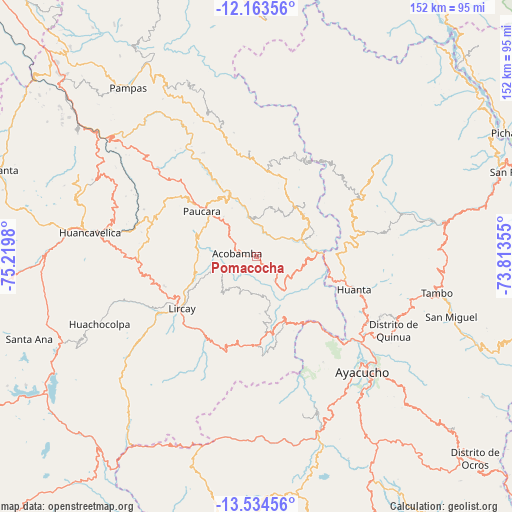
Pomacocha GPS coordinates[2]
12° 51' 0" South, 74° 31' 0.012" West
| Map corner | latitude | longitude |
|---|---|---|
| Upper-left | -12.16356°, | -75.2198° |
| Center: | -12.85°, | -74.51667° |
| Lower-right: | -13.53456°, | -73.81355° |
| Map W x H: | 152.4×152.4 km | = 94.7×94.7mi |
| max Lat: | -0.96667° ⇑59.8% North |
| Pomacocha: | -12.85° |
| min Lat: | ⇓40.2% South -18.01465° |
| min Long | Pomacocha | max Long |
| -81.30472° | -74.51667° | -69.04167° |
| W 62%⇐ | ⇒38% E |
Elevation
Elevation of Pomacocha is 3501 m = 11486 ft, and this is 1182.3 m = 3879 ft above average elevation for this country.
| Max E: |
5022 m = 16476 ft | 20.9% |
| Pomacocha | 3501 m 11486 ft | |
| Avg. | 2318.7 m = 7607 ft | |
Min E: |
1 m = 3 ft | 79.1% |
See also: Peru elevation on elevation.city.
Geographical zone
Pomacocha is located in South Torrid zone (between Equator and Tropic of Capricorn). Distance of this Southern Tropic circle is 1177.1 km =731.4 mi to South.| Distance of | km | miles | from Pomacocha |
|---|---|---|---|
| Equator | 1428.8 | 887.8 | to North |
| Tropic Capricorn | 1177.1 | 731.4 | to South |
| Antarctic Circle | 5972.4 | 3711.1 | to South |
| South Pole | 8578.3 | 5330.3 | to South |


Nearby cities:
15 places around Pomacocha: (largest is in red/bold)
• Acobamba
5.7 km =3.5 mi,  251°
251°
• Anchonga
20.2 km =12.6 mi,  259°
259°
• Antaparco
27.3 km =17 mi,  155°
155°
• Caja
6.6 km =4.1 mi,  124°
124°
• Callanmarca
12.8 km =8 mi, 261°
• Chincho
20.8 km =12.9 mi,  128°
128°
• Churcampa
20.9 km =13 mi,  37°
37°
• Huanta
30.4 km =18.9 mi,  107°
107°
• Julcamarca
19.8 km =12.3 mi, 155°
• La Esmeralda
25.7 km =16 mi,  339°
339°
• Lircay
27.3 km =17 mi,  232°
232°
• Locroja
20.6 km =12.8 mi,  25°
25°
• Luricocha
27.1 km =16.8 mi,  90°
90°
• Marcas
14.9 km =9.3 mi,  104°
104°
• Mayocc
14.7 km =9.1 mi,  59°
59°
Sources, notices
• [Note1] Compared only with cities in Peru existing in our database
• [Src1] Map data: © OpenStreetMap contributors (CC-BY-SA)
• [Src2] Other city data from geonames.org with taken over terms of usage.
• [Src3] Geographical zone / Annual Mean Temperature by Robert A. Rohde @ Wikipedia
