Oropesa geodata
Oropesa (Cusco) is a seat of a third-order administrative division; located in Peru in America/Lima (GMT-5) time zone. With population of 4,022 people, there are 268 cities with bigger population in this country. Compared to other cities in Peru, 68% of cities are located further ↑North; 82.7% of cities are located further ←West and 57.7% of cities have lower elevation than Oropesa. Note1


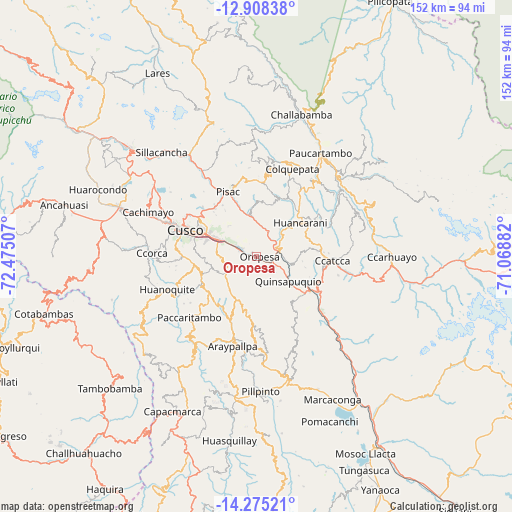
Oropesa GPS coordinates[2]
13° 35' 34.008" South, 71° 46' 18.984" West
| Map corner | latitude | longitude |
|---|---|---|
| Upper-left | -12.90838°, | -72.47507° |
| Center: | -13.59278°, | -71.77194° |
| Lower-right: | -14.27521°, | -71.06882° |
| Map W x H: | 152×152 km | = 94.4×94.4mi |
| max Lat: | -0.96667° ⇑68% North |
| Oropesa: | -13.59278° |
| min Lat: | ⇓32% South -18.01465° |
| min Long | Oropesa | max Long |
| -81.30472° | -71.77194° | -69.04167° |
| W 82.7%⇐ | ⇒17.3% E |
Elevation
Elevation of Oropesa is 3096 m = 10157 ft, and this is 777.3 m = 2550 ft above average elevation for this country.
| Max E: |
5022 m = 16476 ft | 42.3% |
| Oropesa | 3096 m 10157 ft | |
| Avg. | 2318.7 m = 7607 ft | |
Min E: |
1 m = 3 ft | 57.7% |
See also: Peru elevation on elevation.city.
Geographical zone
Oropesa is located in South Torrid zone (between Equator and Tropic of Capricorn). Distance of this Southern Tropic circle is 1094.5 km =680.1 mi to South.| Distance of | km | miles | from Oropesa |
|---|---|---|---|
| Equator | 1511.4 | 939.1 | to North |
| Tropic Capricorn | 1094.5 | 680.1 | to South |
| Antarctic Circle | 5889.8 | 3659.8 | to South |
| South Pole | 8495.7 | 5279 | to South |


Nearby cities:
15 places around Oropesa: (largest is in red/bold)
• Andahuaylillas
13.4 km =8.3 mi,  131°
131°
• Caicay
7.8 km =4.8 mi,  91°
91°
• Ccatca
23 km =14.3 mi, 93°
• Coya
26.6 km =16.5 mi,  328°
328°
• Cusco
22.5 km =14 mi,  290°
290°
• Huaro
18.1 km =11.2 mi, 125°
• Lucre
6 km =3.7 mi,  141°
141°
• Paccaritambo
27.1 km =16.8 mi,  226°
226°
• Paruro
20.7 km =12.9 mi,  203°
203°
• Pisac
20.6 km =12.8 mi,  336°
336°
• San Salvador
11 km =6.8 mi,  358°
358°
• Saylla
9 km =5.6 mi, 292°
• Taray
21.1 km =13.1 mi, 330°
• Urcos
19.2 km =11.9 mi,  122°
122°
• Yaurisque
18.1 km =11.2 mi,  242°
242°
Sources, notices
• [Note1] Compared only with cities in Peru existing in our database
• [Src1] Map data: © OpenStreetMap contributors (CC-BY-SA)
• [Src2] Other city data from geonames.org with taken over terms of usage.
• [Src3] Geographical zone / Annual Mean Temperature by Robert A. Rohde @ Wikipedia
