Taray geodata
Taray (Cusco) is a seat of a third-order administrative division; located in Peru in America/Lima (GMT-5) time zone. In our database, there are 305 cities with bigger population. Compared to other cities in Peru, 65.6% of cities are located further ↑North; 81.7% of cities are located further ←West and 53.4% of cities have lower elevation than Taray. Note1


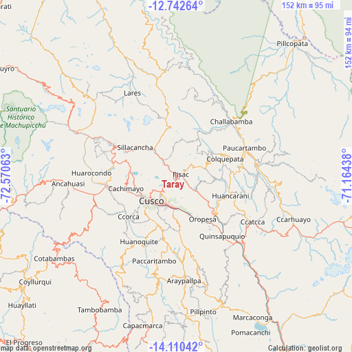
Taray GPS coordinates[2]
13° 25' 39" South, 71° 52' 3" West
| Map corner | latitude | longitude |
|---|---|---|
| Upper-left | -12.74264°, | -72.57063° |
| Center: | -13.4275°, | -71.8675° |
| Lower-right: | -14.11042°, | -71.16438° |
| Map W x H: | 152.1×152.1 km | = 94.5×94.5mi |
| max Lat: | -0.96667° ⇑65.6% North |
| Taray: | -13.4275° |
| min Lat: | ⇓34.4% South -18.01465° |
| min Long | Taray | max Long |
| -81.30472° | -71.8675° | -69.04167° |
| W 81.7%⇐ | ⇒18.3% E |
Elevation
Elevation of Taray is 2978 m = 9770 ft, and this is 659.3 m = 2163 ft above average elevation for this country.
| Max E: |
5022 m = 16476 ft | 46.6% |
| Taray | 2978 m 9770 ft | |
| Avg. | 2318.7 m = 7607 ft | |
Min E: |
1 m = 3 ft | 53.4% |
See also: Peru elevation on elevation.city.
Geographical zone
Taray is located in South Torrid zone (between Equator and Tropic of Capricorn). Distance of this Southern Tropic circle is 1112.9 km =691.5 mi to South.| Distance of | km | miles | from Taray |
|---|---|---|---|
| Equator | 1493 | 927.7 | to North |
| Tropic Capricorn | 1112.9 | 691.5 | to South |
| Antarctic Circle | 5908.2 | 3671.2 | to South |
| South Pole | 8514.1 | 5290.4 | to South |


Nearby cities:
15 places around Taray: (largest is in red/bold)
• Cachimayo
22.8 km =14.2 mi,  256°
256°
• Caicay
26 km =16.2 mi,  135°
135°
• Calca
13.8 km =8.6 mi,  319°
319°
• Chinchero
19.9 km =12.4 mi,  281°
281°
• Colquepata
22.8 km =14.2 mi,  69°
69°
• Coya
5.6 km =3.5 mi, 321°
• Cusco
15.1 km =9.4 mi,  225°
225°
• Huayllabamba
23.6 km =14.7 mi,  294°
294°
• Lamay
9.3 km =5.8 mi, 319°
• Oropesa
21.1 km =13.1 mi,  150°
150°
• Pisac
2.3 km =1.4 mi,  76°
76°
• Poroy
20.4 km =12.7 mi,  248°
248°
• San Salvador
12.5 km =7.8 mi,  125°
125°
• Saylla
15 km =9.3 mi,  172°
172°
• Yucay
26.1 km =16.2 mi,  296°
296°
Sources, notices
• [Note1] Compared only with cities in Peru existing in our database
• [Src1] Map data: © OpenStreetMap contributors (CC-BY-SA)
• [Src2] Other city data from geonames.org with taken over terms of usage.
• [Src3] Geographical zone / Annual Mean Temperature by Robert A. Rohde @ Wikipedia
