Lincha geodata
Lincha (Lima region) is a seat of a third-order administrative division; located in Peru in America/Lima (GMT-5) time zone. In our database, there are 305 cities with bigger population. Compared to other cities in Peru, 59.4% of cities are located further ↑North; 50.9% of cities are located further ←West and 78.5% of cities have lower elevation than Lincha. Note1


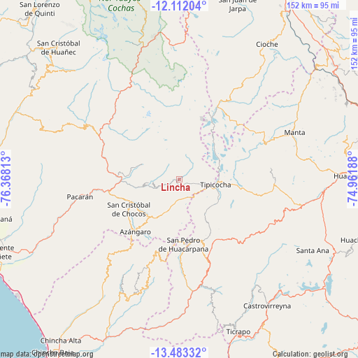
Lincha GPS coordinates[2]
12° 47' 54.996" South, 75° 39' 54" West
| Map corner | latitude | longitude |
|---|---|---|
| Upper-left | -12.11204°, | -76.36813° |
| Center: | -12.79861°, | -75.665° |
| Lower-right: | -13.48332°, | -74.96188° |
| Map W x H: | 152.5×152.5 km | = 94.8×94.8mi |
| max Lat: | -0.96667° ⇑59.4% North |
| Lincha: | -12.79861° |
| min Lat: | ⇓40.6% South -18.01465° |
| min Long | Lincha | max Long |
| -81.30472° | -75.665° | -69.04167° |
| W 50.9%⇐ | ⇒49.1% E |
Elevation
Elevation of Lincha is 3489 m = 11447 ft, and this is 1170.3 m = 3840 ft above average elevation for this country.
| Max E: |
5022 m = 16476 ft | 21.5% |
| Lincha | 3489 m 11447 ft | |
| Avg. | 2318.7 m = 7607 ft | |
Min E: |
1 m = 3 ft | 78.5% |
See also: Peru elevation on elevation.city.
Geographical zone
Lincha is located in South Torrid zone (between Equator and Tropic of Capricorn). Distance of this Southern Tropic circle is 1182.8 km =735 mi to South.| Distance of | km | miles | from Lincha |
|---|---|---|---|
| Equator | 1423.1 | 884.3 | to North |
| Tropic Capricorn | 1182.8 | 735 | to South |
| Antarctic Circle | 5978.1 | 3714.6 | to South |
| South Pole | 8584 | 5333.8 | to South |


Nearby cities:
15 places around Lincha: (largest is in red/bold)
• Acobambilla
34.7 km =21.6 mi,  61°
61°
• Arma
38.1 km =23.7 mi,  158°
158°
• Cacra
12.9 km =8 mi,  262°
262°
• Catahuasi
24.6 km =15.3 mi,  269°
269°
• Chocos
25 km =15.5 mi,  239°
239°
• Chupamarca
27 km =16.8 mi, 164°
• Colonia
30.6 km =19 mi,  307°
307°
• Hongos
10.9 km =6.8 mi, 262°
• Huamatambo
35.4 km =22 mi,  183°
183°
• Huangascar
21.2 km =13.2 mi, 238°
• Madean
20.2 km =12.6 mi,  216°
216°
• San Juan
44.7 km =27.8 mi, 177°
• Tupe
16.8 km =10.4 mi,  292°
292°
• Viñac
19.2 km =11.9 mi, 219°
• Yauyos
46.6 km =29 mi,  324°
324°
Sources, notices
• [Note1] Compared only with cities in Peru existing in our database
• [Src1] Map data: © OpenStreetMap contributors (CC-BY-SA)
• [Src2] Other city data from geonames.org with taken over terms of usage.
• [Src3] Geographical zone / Annual Mean Temperature by Robert A. Rohde @ Wikipedia
