Arma geodata
Arma (Huancavelica) is a seat of a third-order administrative division; located in Peru in America/Lima (GMT-5) time zone. In our database, there are 305 cities with bigger population. Compared to other cities in Peru, 62.5% of cities are located further ↑North; 52% of cities are located further ←West and 93.2% of cities have lower elevation than Arma. Note1
Administrative division(s):
- Level 1: Huancavelica
- Level 2: Provincia de Castrovirreyna
- Level 3: Arma


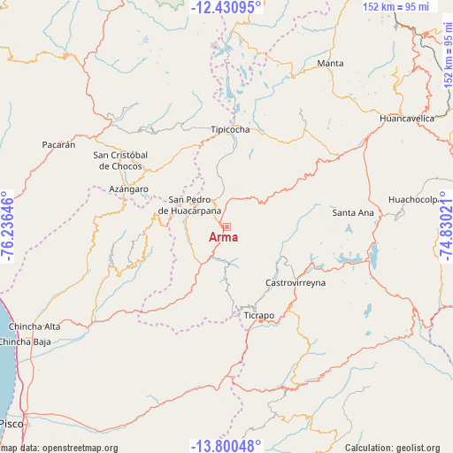
Arma GPS coordinates[2]
13° 7' 0.012" South, 75° 31' 59.988" West
| Map corner | latitude | longitude |
|---|---|---|
| Upper-left | -12.43095°, | -76.23646° |
| Center: | -13.11667°, | -75.53333° |
| Lower-right: | -13.80048°, | -74.83021° |
| Map W x H: | 152.3×152.3 km | = 94.6×94.6mi |
| max Lat: | -0.96667° ⇑62.5% North |
| Arma: | -13.11667° |
| min Lat: | ⇓37.5% South -18.01465° |
| min Long | Arma | max Long |
| -81.30472° | -75.53333° | -69.04167° |
| W 52%⇐ | ⇒48% E |
Elevation
Elevation of Arma is 3938 m = 12920 ft, and this is 1619.3 m = 5313 ft above average elevation for this country.
| Max E: |
5022 m = 16476 ft | 6.8% |
| Arma | 3938 m 12920 ft | |
| Avg. | 2318.7 m = 7607 ft | |
Min E: |
1 m = 3 ft | 93.2% |
See also: Peru elevation on elevation.city.
Geographical zone
Arma is located in South Torrid zone (between Equator and Tropic of Capricorn). Distance of this Southern Tropic circle is 1147.5 km =713 mi to South.| Distance of | km | miles | from Arma |
|---|---|---|---|
| Equator | 1458.4 | 906.2 | to North |
| Tropic Capricorn | 1147.5 | 713 | to South |
| Antarctic Circle | 5942.7 | 3692.6 | to South |
| South Pole | 8548.6 | 5311.9 | to South |


Nearby cities:
15 places around Arma: (largest is in red/bold)
• Cacra
43.3 km =26.9 mi,  321°
321°
• Castrovirreyna
28.8 km =17.9 mi,  125°
125°
• Chocos
42.2 km =26.2 mi,  302°
302°
• Chupamarca
11.7 km =7.3 mi, 322°
• Cocas
24.6 km =15.3 mi, 132°
• Hongos
42.2 km =26.2 mi, 323°
• Huachos
9.4 km =5.8 mi,  168°
168°
• Huamatambo
16.2 km =10.1 mi,  270°
270°
• Huangascar
40.3 km =25 mi,  306°
306°
• Lincha
38.1 km =23.7 mi,  338°
338°
• Madean
32.6 km =20.3 mi, 305°
• Mollepampa
25 km =15.5 mi,  144°
144°
• San Juan
15.7 km =9.8 mi,  233°
233°
• Ticrapo
28.9 km =18 mi,  154°
154°
• Viñac
33.6 km =20.9 mi, 307°
Sources, notices
• [Note1] Compared only with cities in Peru existing in our database
• [Src1] Map data: © OpenStreetMap contributors (CC-BY-SA)
• [Src2] Other city data from geonames.org with taken over terms of usage.
• [Src3] Geographical zone / Annual Mean Temperature by Robert A. Rohde @ Wikipedia
