Limatambo geodata
Limatambo (Cusco) is a seat of a third-order administrative division; located in Peru in America/Lima (GMT-5) time zone. In our database, there are 305 cities with bigger population. Compared to other cities in Peru, 66.2% of cities are located further ↑North; 77.9% of cities are located further ←West and 56.6% of cities have higher elevation than Limatambo. Note1


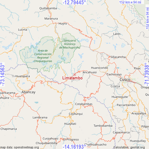
Limatambo GPS coordinates[2]
13° 28' 45.012" South, 72° 26' 33" West
| Map corner | latitude | longitude |
|---|---|---|
| Upper-left | -12.79445°, | -73.14563° |
| Center: | -13.47917°, | -72.4425° |
| Lower-right: | -14.16193°, | -71.73938° |
| Map W x H: | 152×152.1 km | = 94.4×94.5mi |
| max Lat: | -0.96667° ⇑66.2% North |
| Limatambo: | -13.47917° |
| min Lat: | ⇓33.8% South -18.01465° |
| min Long | Limatambo | max Long |
| -81.30472° | -72.4425° | -69.04167° |
| W 77.9%⇐ | ⇒22.1% E |
Elevation
Elevation of Limatambo is 2607 m = 8553 ft, and this is 288.3 m = 946 ft above average elevation for this country.
| Max E: |
5022 m = 16476 ft | 56.6% |
| Limatambo | 2607 m 8553 ft | |
| Avg. | 2318.7 m = 7607 ft | |
Min E: |
1 m = 3 ft | 43.4% |
See also: Peru elevation on elevation.city.
Geographical zone
Limatambo is located in South Torrid zone (between Equator and Tropic of Capricorn). Distance of this Southern Tropic circle is 1107.2 km =688 mi to South.| Distance of | km | miles | from Limatambo |
|---|---|---|---|
| Equator | 1498.7 | 931.2 | to North |
| Tropic Capricorn | 1107.2 | 688 | to South |
| Antarctic Circle | 5902.4 | 3667.6 | to South |
| South Pole | 8508.3 | 5286.8 | to South |


Nearby cities:
15 places around Limatambo: (largest is in red/bold)
• Ancahuasi
14.8 km =9.2 mi,  74°
74°
• Anta
31.8 km =19.8 mi,  88°
88°
• Cachimayo
40 km =24.9 mi, 89°
• Cachora
39.9 km =24.8 mi,  264°
264°
• Chinchaypujio
28.2 km =17.5 mi,  126°
126°
• Cotabambas
31.1 km =19.3 mi,  162°
162°
• Coyllurqui
39.7 km =24.7 mi,  178°
178°
• Curahuasi
28.9 km =18 mi,  254°
254°
• Huarocondo
26.6 km =16.5 mi, 74°
• Maras
34.8 km =21.6 mi,  62°
62°
• Ollantaytambo
31.4 km =19.5 mi,  38°
38°
• Pucyura
35.8 km =22.2 mi, 89°
• Santa Teresa
41.8 km =26 mi,  337°
337°
• Urubamba
40.3 km =25 mi, 61°
• Zurite
20.4 km =12.7 mi,  82°
82°
Sources, notices
• [Note1] Compared only with cities in Peru existing in our database
• [Src1] Map data: © OpenStreetMap contributors (CC-BY-SA)
• [Src2] Other city data from geonames.org with taken over terms of usage.
• [Src3] Geographical zone / Annual Mean Temperature by Robert A. Rohde @ Wikipedia
