Anta geodata
Anta (Cusco) is a seat of a third-order administrative division; located in Peru in America/Lima (GMT-5) time zone. With population of 5,859 people, there are 212 cities with bigger population in this country. Compared to other cities in Peru, 65.9% of cities are located further ↑North; 79.3% of cities are located further ←West and 74.8% of cities have lower elevation than Anta. Note1


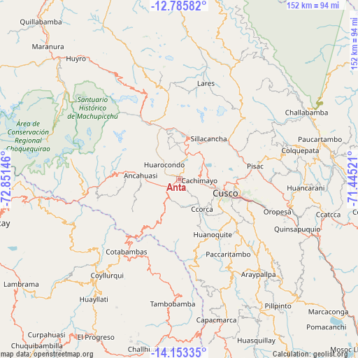
Anta GPS coordinates[2]
13° 28' 14.016" South, 72° 8' 53.988" West
| Map corner | latitude | longitude |
|---|---|---|
| Upper-left | -12.78582°, | -72.85146° |
| Center: | -13.47056°, | -72.14833° |
| Lower-right: | -14.15335°, | -71.44521° |
| Map W x H: | 152.1×152.1 km | = 94.5×94.5mi |
| max Lat: | -0.96667° ⇑65.9% North |
| Anta: | -13.47056° |
| min Lat: | ⇓34.1% South -18.01465° |
| min Long | Anta | max Long |
| -81.30472° | -72.14833° | -69.04167° |
| W 79.3%⇐ | ⇒20.7% E |
Elevation
Elevation of Anta is 3431 m = 11257 ft, and this is 1112.3 m = 3649 ft above average elevation for this country.
| Max E: |
5022 m = 16476 ft | 25.2% |
| Anta | 3431 m 11257 ft | |
| Avg. | 2318.7 m = 7607 ft | |
Min E: |
1 m = 3 ft | 74.8% |
See also: Peru elevation on elevation.city.
Geographical zone
Anta is located in South Torrid zone (between Equator and Tropic of Capricorn). Distance of this Southern Tropic circle is 1108.1 km =688.5 mi to South.| Distance of | km | miles | from Anta |
|---|---|---|---|
| Equator | 1497.8 | 930.7 | to North |
| Tropic Capricorn | 1108.1 | 688.5 | to South |
| Antarctic Circle | 5903.4 | 3668.2 | to South |
| South Pole | 8509.3 | 5287.4 | to South |


Nearby cities:
15 places around Anta: (largest is in red/bold)
• Ancahuasi
17.8 km =11.1 mi,  280°
280°
• Cachimayo
8.3 km =5.2 mi,  94°
94°
• Calca
26.3 km =16.3 mi,  54°
54°
• Ccorca
15.9 km =9.9 mi,  143°
143°
• Chinchaypujio
20 km =12.4 mi,  207°
207°
• Chinchero
13.9 km =8.6 mi, 51°
• Cusco
20.4 km =12.7 mi,  106°
106°
• Huarocondo
8.9 km =5.5 mi,  315°
315°
• Huayllabamba
17.3 km =10.7 mi,  31°
31°
• Maras
15.1 km =9.4 mi,  356°
356°
• Poroy
11.7 km =7.3 mi,  103°
103°
• Pucyura
4.1 km =2.5 mi, 103°
• Urubamba
18.8 km =11.7 mi,  10°
10°
• Yucay
18.1 km =11.2 mi,  23°
23°
• Zurite
11.7 km =7.3 mi, 278°
Sources, notices
• [Note1] Compared only with cities in Peru existing in our database
• [Src1] Map data: © OpenStreetMap contributors (CC-BY-SA)
• [Src2] Other city data from geonames.org with taken over terms of usage.
• [Src3] Geographical zone / Annual Mean Temperature by Robert A. Rohde @ Wikipedia
