Huarocondo geodata
Huarocondo (Cusco) is a seat of a third-order administrative division; located in Peru in America/Lima (GMT-5) time zone. In our database, there are 305 cities with bigger population. Compared to other cities in Peru, 65.4% of cities are located further ↑North; 78.9% of cities are located further ←West and 69.2% of cities have lower elevation than Huarocondo. Note1


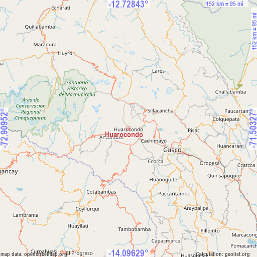
Huarocondo GPS coordinates[2]
13° 24' 47.988" South, 72° 12' 23.004" West
| Map corner | latitude | longitude |
|---|---|---|
| Upper-left | -12.72843°, | -72.90952° |
| Center: | -13.41333°, | -72.20639° |
| Lower-right: | -14.09629°, | -71.50327° |
| Map W x H: | 152.1×152.1 km | = 94.5×94.5mi |
| max Lat: | -0.96667° ⇑65.4% North |
| Huarocondo: | -13.41333° |
| min Lat: | ⇓34.6% South -18.01465° |
| min Long | Huarocondo | max Long |
| -81.30472° | -72.20639° | -69.04167° |
| W 78.9%⇐ | ⇒21.1% E |
Elevation
Elevation of Huarocondo is 3329 m = 10922 ft, and this is 1010.3 m = 3315 ft above average elevation for this country.
| Max E: |
5022 m = 16476 ft | 30.8% |
| Huarocondo | 3329 m 10922 ft | |
| Avg. | 2318.7 m = 7607 ft | |
Min E: |
1 m = 3 ft | 69.2% |
See also: Peru elevation on elevation.city.
Geographical zone
Huarocondo is located in South Torrid zone (between Equator and Tropic of Capricorn). Distance of this Southern Tropic circle is 1114.5 km =692.5 mi to South.| Distance of | km | miles | from Huarocondo |
|---|---|---|---|
| Equator | 1491.4 | 926.7 | to North |
| Tropic Capricorn | 1114.5 | 692.5 | to South |
| Antarctic Circle | 5909.8 | 3672.2 | to South |
| South Pole | 8515.6 | 5291.3 | to South |


Nearby cities:
15 places around Huarocondo: (largest is in red/bold)
• Ancahuasi
11.8 km =7.3 mi,  253°
253°
• Anta
8.9 km =5.5 mi,  135°
135°
• Cachimayo
16.1 km =10 mi,  115°
115°
• Ccorca
24.8 km =15.4 mi, 140°
• Chinchaypujio
24.3 km =15.1 mi,  186°
186°
• Chinchero
17.3 km =10.7 mi,  82°
82°
• Huayllabamba
17.4 km =10.8 mi,  61°
61°
• Limatambo
26.6 km =16.5 mi, 254°
• Maras
10.2 km =6.3 mi,  31°
31°
• Ollantaytambo
18.4 km =11.4 mi,  340°
340°
• Poroy
19.8 km =12.3 mi, 117°
• Pucyura
12.6 km =7.8 mi,  125°
125°
• Urubamba
15.6 km =9.7 mi,  39°
39°
• Yucay
16.9 km =10.5 mi,  52°
52°
• Zurite
7 km =4.3 mi,  229°
229°
Sources, notices
• [Note1] Compared only with cities in Peru existing in our database
• [Src1] Map data: © OpenStreetMap contributors (CC-BY-SA)
• [Src2] Other city data from geonames.org with taken over terms of usage.
• [Src3] Geographical zone / Annual Mean Temperature by Robert A. Rohde @ Wikipedia
