Lampa geodata
Lampa (Ayacucho) is a seat of a third-order administrative division; located in Peru in America/Lima (GMT-5) time zone. In our database, there are 305 cities with bigger population. Compared to other cities in Peru, 86.7% of cities are located further ↑North; 70.8% of cities are located further ←West and 51.5% of cities have higher elevation than Lampa. Note1


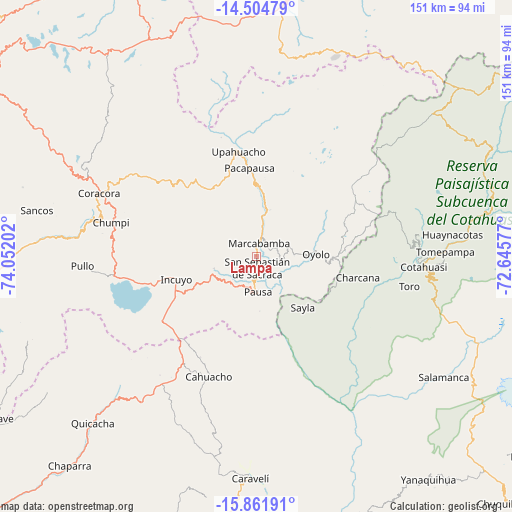
Lampa GPS coordinates[2]
15° 11' 3.984" South, 73° 20' 56.004" West
| Map corner | latitude | longitude |
|---|---|---|
| Upper-left | -14.50479°, | -74.05202° |
| Center: | -15.18444°, | -73.34889° |
| Lower-right: | -15.86191°, | -72.64577° |
| Map W x H: | 150.9×150.9 km | = 93.8×93.8mi |
| max Lat: | -0.96667° ⇑86.7% North |
| Lampa: | -15.18444° |
| min Lat: | ⇓13.3% South -18.01465° |
| min Long | Lampa | max Long |
| -81.30472° | -73.34889° | -69.04167° |
| W 70.8%⇐ | ⇒29.2% E |
Elevation
Elevation of Lampa is 2797 m = 9177 ft, and this is 478.3 m = 1569 ft above average elevation for this country.
| Max E: |
5022 m = 16476 ft | 51.5% |
| Lampa | 2797 m 9177 ft | |
| Avg. | 2318.7 m = 7607 ft | |
Min E: |
1 m = 3 ft | 48.5% |
See also: Peru elevation on elevation.city.
Geographical zone
Lampa is located in South Torrid zone (between Equator and Tropic of Capricorn). Distance of this Southern Tropic circle is 917.6 km =570.2 mi to South.| Distance of | km | miles | from Lampa |
|---|---|---|---|
| Equator | 1688.4 | 1049.1 | to North |
| Tropic Capricorn | 917.6 | 570.2 | to South |
| Antarctic Circle | 5712.8 | 3549.8 | to South |
| South Pole | 8318.7 | 5169 | to South |


Nearby cities:
15 places around Lampa: (largest is in red/bold)
• Aniso
42.2 km =26.2 mi,  8°
8°
• Cahuacho
38.4 km =23.9 mi,  201°
201°
• Charcana
30.5 km =19 mi,  101°
101°
• Chumpi
45.8 km =28.5 mi,  281°
281°
• Colta
6.3 km =3.9 mi,  66°
66°
• Corculla
18.1 km =11.2 mi,  118°
118°
• Incuyo
26.2 km =16.3 mi,  253°
253°
• Marcabamba
3.8 km =2.4 mi, 11°
• Oyolo
17.5 km =10.9 mi,  88°
88°
• Pacapausa
26 km =16.2 mi,  355°
355°
• Pausa
10.6 km =6.6 mi,  178°
178°
• Quilcata
13.3 km =8.3 mi,  237°
237°
• Tauria
22.8 km =14.2 mi,  146°
146°
• Upahuacho
31.9 km =19.8 mi,  349°
349°
• Velinga
36.5 km =22.7 mi,  105°
105°
Sources, notices
• [Note1] Compared only with cities in Peru existing in our database
• [Src1] Map data: © OpenStreetMap contributors (CC-BY-SA)
• [Src2] Other city data from geonames.org with taken over terms of usage.
• [Src3] Geographical zone / Annual Mean Temperature by Robert A. Rohde @ Wikipedia
