Corculla geodata
Corculla (Ayacucho) is a seat of a third-order administrative division; located in Peru in America/Lima (GMT-5) time zone. In our database, there are 305 cities with bigger population. Compared to other cities in Peru, 87.7% of cities are located further ↑North; 72.1% of cities are located further ←West and 77.6% of cities have lower elevation than Corculla. Note1


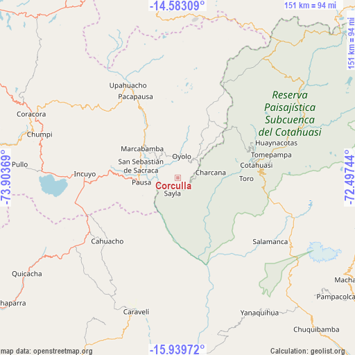
Corculla GPS coordinates[2]
15° 15' 45" South, 73° 12' 2.016" West
| Map corner | latitude | longitude |
|---|---|---|
| Upper-left | -14.58309°, | -73.90369° |
| Center: | -15.2625°, | -73.20056° |
| Lower-right: | -15.93972°, | -72.49744° |
| Map W x H: | 150.8×150.8 km | = 93.7×93.7mi |
| max Lat: | -0.96667° ⇑87.7% North |
| Corculla: | -15.2625° |
| min Lat: | ⇓12.3% South -18.01465° |
| min Long | Corculla | max Long |
| -81.30472° | -73.20056° | -69.04167° |
| W 72.1%⇐ | ⇒27.9% E |
Elevation
Elevation of Corculla is 3482 m = 11424 ft, and this is 1163.3 m = 3817 ft above average elevation for this country.
| Max E: |
5022 m = 16476 ft | 22.4% |
| Corculla | 3482 m 11424 ft | |
| Avg. | 2318.7 m = 7607 ft | |
Min E: |
1 m = 3 ft | 77.6% |
See also: Peru elevation on elevation.city.
Geographical zone
Corculla is located in South Torrid zone (between Equator and Tropic of Capricorn). Distance of this Southern Tropic circle is 908.9 km =564.8 mi to South.| Distance of | km | miles | from Corculla |
|---|---|---|---|
| Equator | 1697 | 1054.5 | to North |
| Tropic Capricorn | 908.9 | 564.8 | to South |
| Antarctic Circle | 5704.1 | 3544.4 | to South |
| South Pole | 8310 | 5163.6 | to South |


Nearby cities:
15 places around Corculla: (largest is in red/bold)
• Cahuacho
40.3 km =25 mi,  227°
227°
• Charcana
14.1 km =8.8 mi,  80°
80°
• Colta
15 km =9.3 mi,  317°
317°
• Cotahuasi
33.9 km =21.1 mi, 80°
• Lampa
18.1 km =11.2 mi,  298°
298°
• Marcabamba
19.6 km =12.2 mi,  309°
309°
• Mungui
32.9 km =20.4 mi,  74°
74°
• Oyolo
9.3 km =5.8 mi,  9°
9°
• Pacapausa
39 km =24.2 mi,  332°
332°
• Pausa
15.7 km =9.8 mi,  262°
262°
• Quilcata
27.2 km =16.9 mi,  273°
273°
• Tauria
11 km =6.8 mi,  198°
198°
• Taurisma
38.8 km =24.1 mi, 75°
• Toro
29.1 km =18.1 mi,  90°
90°
• Velinga
19.2 km =11.9 mi, 93°
Sources, notices
• [Note1] Compared only with cities in Peru existing in our database
• [Src1] Map data: © OpenStreetMap contributors (CC-BY-SA)
• [Src2] Other city data from geonames.org with taken over terms of usage.
• [Src3] Geographical zone / Annual Mean Temperature by Robert A. Rohde @ Wikipedia
