Lambrama geodata
Lambrama (Apurímac) is a seat of a third-order administrative division; located in Peru in America/Lima (GMT-5) time zone. In our database, there are 305 cities with bigger population. Compared to other cities in Peru, 72.1% of cities are located further ↑North; 75.2% of cities are located further ←West and 61% of cities have lower elevation than Lambrama. Note1


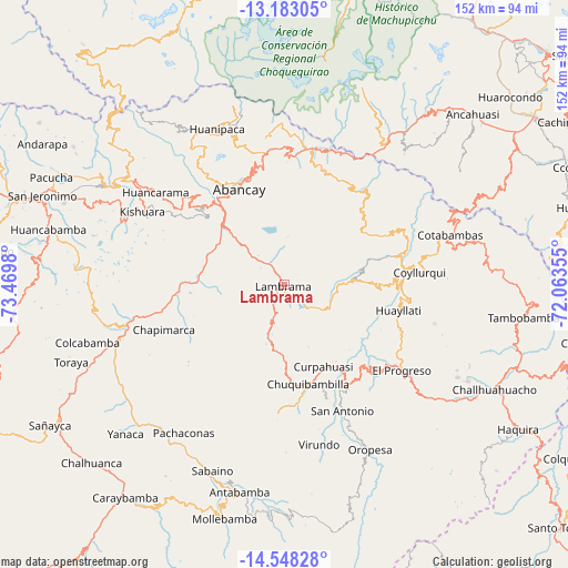
Lambrama GPS coordinates[2]
13° 52' 0.012" South, 72° 46' 0.012" West
| Map corner | latitude | longitude |
|---|---|---|
| Upper-left | -13.18305°, | -73.4698° |
| Center: | -13.86667°, | -72.76667° |
| Lower-right: | -14.54828°, | -72.06355° |
| Map W x H: | 151.8×151.8 km | = 94.3×94.3mi |
| max Lat: | -0.96667° ⇑72.1% North |
| Lambrama: | -13.86667° |
| min Lat: | ⇓27.9% South -18.01465° |
| min Long | Lambrama | max Long |
| -81.30472° | -72.76667° | -69.04167° |
| W 75.2%⇐ | ⇒24.8% E |
Elevation
Elevation of Lambrama is 3182 m = 10440 ft, and this is 863.3 m = 2832 ft above average elevation for this country.
| Max E: |
5022 m = 16476 ft | 39% |
| Lambrama | 3182 m 10440 ft | |
| Avg. | 2318.7 m = 7607 ft | |
Min E: |
1 m = 3 ft | 61% |
See also: Peru elevation on elevation.city.
Geographical zone
Lambrama is located in South Torrid zone (between Equator and Tropic of Capricorn). Distance of this Southern Tropic circle is 1064.1 km =661.2 mi to South.| Distance of | km | miles | from Lambrama |
|---|---|---|---|
| Equator | 1541.8 | 958 | to North |
| Tropic Capricorn | 1064.1 | 661.2 | to South |
| Antarctic Circle | 5859.3 | 3640.8 | to South |
| South Pole | 8465.2 | 5260 | to South |


Nearby cities:
15 places around Lambrama: (largest is in red/bold)
• Abancay
28.7 km =17.8 mi,  334°
334°
• Ayrihuanca
31.3 km =19.4 mi,  147°
147°
• Chapimarca
34.4 km =21.4 mi,  249°
249°
• Chuquibambilla
26.9 km =16.7 mi,  166°
166°
• Circa
11.5 km =7.1 mi,  265°
265°
• Curahuasi
35.9 km =22.3 mi,  11°
11°
• Curpahuasi
24.1 km =15 mi, 154°
• Huayllati
31.3 km =19.4 mi,  102°
102°
• Palpacachi
28.4 km =17.6 mi,  90°
90°
• Pataypampa
35.7 km =22.2 mi,  163°
163°
• Pichirhua
33.1 km =20.6 mi, 271°
• San Pedro De Cachora
28.8 km =17.9 mi, 334°
• Santa Rosa
33.3 km =20.7 mi, 161°
• Tamburco
30 km =18.6 mi,  337°
337°
• Vilcabamba
27.8 km =17.3 mi, 146°
Sources, notices
• [Note1] Compared only with cities in Peru existing in our database
• [Src1] Map data: © OpenStreetMap contributors (CC-BY-SA)
• [Src2] Other city data from geonames.org with taken over terms of usage.
• [Src3] Geographical zone / Annual Mean Temperature by Robert A. Rohde @ Wikipedia
